 |
Don Lancaster's
Gila ValleyDay Hikes |
|
|
|||
| Click here for the latest updates! |
| Click here for the new canal menu! |
| Click here for the CMOS Cookbook! |
| Click here for our JFA Preprint! |
| Click here for the canal images! |
| Click here for my ARA Video! |
| home | new | rss | eBay | xml | top | bot |
Please note that the Guru's Lair is best used with larger display systems. Especially for our many ebooks, classic .pdf files and high detail images.
| Pick your blog year... | ||||
| 1997 | 1998 | 1999 | 2000 | 2001 |
| 2002 | 2003 | 2004 | 2005 | 2006 |
| 2007 | 2008 | 2009 | 2010 | 2011 |
| 2012 | 2013 | 2014 | 2015 | 2016 |
| 2017 | 2018 | 2019 | 2020 | ----- |
What it is all about
deeplink • top • bot • respond
Over the years, I've managed to make at least one trip somewhere just about every week forever. Some for caving, some for prehistoric canals, some for tinaja quests, some for escape, some for Bed and Breakfasts, and some as plain old dog walks or day hikes.
I thought I might compile a list of nearby Gila Valley day hikes here. More than a few of which even the natives have never heard of.
I've newly provided lat-lon text links on many of these locations. but certain sensitive areas involving Indian habitation sites, some caves, paleo stuff, and a few other location have been purposely omitted.
I've personally visited nearly all of these sites at least once. While many are close in, a very few of the more intriguing locations may involve an hour's drive or so from the greater Bonita-Eden-Sanchez metropolitan area.
Please note that many of our location links lead to Acme Mapper. Which tends to remember your previous use history. It is always a good idea to clear all of your earlier markers often and to start off with USA Topo coverage. Note further that USA Topo coverage is not available on the higher magnifications.
Please report your own additions, corrections, present conditions, or comments here.
To gain access, you can select one of these..
But first, you might want to check out some of these...
Or these files of hiking interest that you can find as our...
Dayhikes 1-15
deeplink • top • bot • respond
FRYE MESA FALLS -- Waterfalls, rock scrambling, fishing. Family thru canyoneering. Access recently greatly improved, but last 4WD mile can be very rough.
N 32.74517 W 109.83710
RED KNOLLS -- Has many dozens of pseudokarst pits. These are very easy to rig -- just push the bolts in with your thumb! A recent scientific experiment here verified that if you are going to blow the top off a mesa, it might end up suboptimal to be standing on the mesa at the time. WARNING: Pits are highly unstable and dangerous!
N32.96087 W 109.94031
McENIRY TUNNEL -- One of many local investment scams. This one to tap Mount Graham for water and gold. You simply scraped the gold off the ceiling directly into your ore cars. The last quarter mile of 4WD is usually hiked instead. Original docs here. AKA the Triumph Tunnel.
N 32.77583 W 109.86747
SAFFORD GRIDS -- Incredibly spectacular prehistoric ag structures. Many thousands north of the river, and a few hundred to the south. Possibly used to farm aguaves for mescal. Or possibly the paleo prototypical Dilbert cubicles. Find the definitive book here.
Such as - N 32.92917 W 109.80345
CCC CAMP -- An amazingly close in "ghost town" that seems virtually unknown. Includes buildings, trails, auto service training ramps.
N32.86087 W109.57744
TENSION STATION-- Much of the Mount Graham Tramway is very hard to access. But the first tension station is an easy hike with minimal 4WD needed.
N32.80700 W109.88106
COTTON CAVE -- Site of long removed prehistoric cotton and pottery artifacts a difficult climb above the McEniry Tunnel. Actually a void formed from collapse of Gneiss boulders, rather than a "true" cave. The historic documents appear here and a recent trip report here.
BONITA CREEK -- Nearby wet stream includes Indian ruins, birds, hiking, and history. Note that Lee Trail midway access is strictly limited to 4WD + Granny ONLY!
N32.91551W109.49230
PREHISTORIC HANGING CANALS -- Literally hung on the sides of steep bajada mesas as much as 180 feet (!) above the surrounding terrain. Creating ag complexes many dozens of miles long. This is world class unique engineering far beyond stunning. Over a hundred canal study areas are now known with a total distance above 150 miles! Your participation welcome!
JFA Preprint
Hanging Canal Paper
Canal Image Menu
ARA Video
Wikipedia Story
RINCON SPRING -- Mile long dayhike gives you sweeping valley views. Very seldom traveled. Excellent winter trip. Go north from Marijilda crossing.
N32.72353 W109.79454
DEAD CAMEL PLACE-- Footprints of paleo animals and other Pliocene paleontology. South of the Mackenzie River.
THOSE "ICE CAVES -- Spheroidally weathered granite voids just
below the Grant-Goudy trail once held year long ice. Perhaps sixty feet or so of total depth. Rather overrated. Approach from Soldier Creek Campground.
N32.69479 W 109.91945
GOAT HILL SITE -- Indian ruin on the summit of a small knoll. Dating from the 1300's. Access presently restricted. Other sites nearby.
ZEOLITE MINES -- Thin layers of minerals with an incredible variety of catalytic, filtering, and similar uses. Several different sites in intermittent use south of Hot Wells Dunes and north of Bowie.
Some locations - N 32.46976 W 109.41021
CARTER BOX -- Secret hidden pools here once held native fish. I am not sure what our drought conditions have done recently.
N32.79435 W109.97086
Dayhikes 16-30
deeplink • top • bot • respond
MORENCI CRYSTAL CAVE -- Several hundred feet of limestone passage, typically with a lake blocking some easier access.
HIDDEN GILA ACCESS -- Several obscure ag roads lead to an amazingly pristine river stretch halfway between Pima and Thatcher. Approachable by 4wd from either north or south.
N 32.89068 W 109.79279
ASH CAMP --Nice picnic area with a usually running stream. Flume and mountain access trails further up. Above Cluff ponds. The road above the camp has recently been much improved.
N 32.79710 W 109.85665
MOUNT GRAHAM OBSERVATORY -- Incredible technology. Guided tours only from Discovery Park. Seasonal. Normally no winter access.
Observatory - N 32.70070 W 109.89251
Discovery Park - N 32.80002 W 109.72690
APACHE BOX -- A favorite hiking area of BLM employees just over the NM border. Often includes a wet stream. Nearby Buddhist monastery tours.
N32.93375 W 108.99324
STOCKTON & GILLEPSIE WASHES -- Nice picnic areas. Through hikes down a usually dry stream are easy but only seldom done.
N 32.56892 W 109.76138
HOT WELL DUNES -- BLM hot tubs, sand dunes, offroad vehicle paradise. Enforced dress code.
N 32.52349 W 109.42644
EDEN WATER SPREADERS -- Enigmatic check dams leap out at you from satellite photos. These appear to be mostly CCC water control structures dating from the 1930's.
N 32.96768 W 109.83663
SAN CARLOS FALLS -- Spectacular but rather difficult canyoneering on the res. Rec permit required and enforced.
N 33.43966 W 110.27326
ALLEN RESERVOIR -- Failed flood control dam is rarely visited. Makes for interesting close in exploration. Supposedly once used for water skiing!
N 32.83338 W 109.79374
OAK GROVE CANYON -- Seldom visited and little known feeder canyon to Aravaipa offers a wet stream, tiny fish, cliffs, riparian. Check BLM for access.
N 32.84564 W 110.44502
GOAT WELL DETENTION -- Spectacular San Simon erosional features caused by extreme long term overgrazing.
N 32.70529 W 109.55081
CUNNINGHAM ROADS -- Old logging trails atop Mt. Graham are closed to vehicles but offer superb and easy hiking, horsing, and mountain biking. North of Swift Trail.
N 32.67733W109.88020
GRANT HILL ROADS -- Very similar to the Cunningham Roads, except earlier and to the South of Swift Trail. Superb views.
N 32.66555 W 109.88320
SANTA TERESA ROCK CLIMBING -- World class climbing granite is little known and seldom visited. Klondyke Wall is particularly challenging. As can be parts of Pinnacle Ridge.
N 32.88591 W 110.21275
Dayhikes 31-45
deeplink • top • bot • respond
MARIJILDA PICNIC AREA-- Small pools are perfect for kiddies. Lots of big trees, but fewer because of recent flood damage.
N 32.69925 W 109.78810
MORENCI MINE TOUR -- Commercial tours of one of the largest copper mine in the world are not presently available, but info on planned new ones might be found here. There might still be a nice overview at N 33.08943 W 109.38066 No Safford tours are known at present.
YELLOWSTONE DAM -- Small catchment in scenic area has an unusual flying buttress architecture. Separate from Yellowstone Tank, but in the same area.
N 32.86432 W 109.36343
SAN CARLOS LAKE -- Often the largest lake in the area and offers fishing and boating plus an unusual Coolidge multiple dome dam. Reservation permits required.
N 33.18140 W 110.51023
WEST END MINES -- Historic district east of Duncan offers all sorts of exploration possibilities. Avoid tunnels and shafts!
N 32.81640 W 108.98076
PIMA BOX -- Unusual geological feature forms a short box canyon in the Upper Sonoran life zone. Javelinas and Saguaros common here. The Black Hills Arch is further upcanyon.
Box at - N 33.06978W109.93902
Arch near -N 33.07837 W 109.93464
ROPER LAKE STATE PARK -- Has developed hot springs, lakes with islands, fishing, camping, hiking. Fees charged.
N 32.75522 W 109.70487
FLYING BOXCAR -- Rare static display of a military C119G "flying boxcar" twin boom cargo and paratroop plane at Pima International
Airport, aka the Flying J. Call in advance.
N 32.84627 W 109.88065
LEBANON PONDS -- A pair of fairly large reservoirs that hold seasonal water and provide storage for a historic irrigation district.
Number one at - N 32.73472 W 109.76092
Number two at - N 32.74454 W 109.74718
GILA BOX -- Hiking access to the box itself is difficult, but the white water takeout near the Flying W picnic ground includes superb swimming.
Gila Box a t- N 32.93903 W 109.42824
Flying W at - N 32.88462 W 109.48260
DEADMAN CANYON -- Offers several waterfalls, mid-route
access to the Round the Mountain trail, and an irrigation canal that runs along the highest point on its ridge. A "secret" and seldom traveled track routes backwards and south off Deadman Mesa into the lower canyon.
Main Deadman at - N 32.73890 W 109.81142
Secret track at - N 32.74522 W 109.79824
EAGLE CREEK BAT CAVE -- Early guano mining combined with seasonal bat flights. F-M permit recommended.
N 33.02369 W 109.41273
OLD MARBLE QUARRY -- Historic artifacts in Emigrant Canyon once included steam engines and other equipment. Also rappelling and huge stone blocks. Landowner relations often less than stellar.
N 32.11505 W 109.40300
SAN SIMON BARRIER DAM -- Erosion control structure quickly
filled with mud the instant it was built. Does prove that one of the indicator species of overgrazing is --- > cows.
N 32.78109 W 109.6089
DANKWORTH PONDS -- One time warm spring fish farm offers hiking and day picnicking, trails, and shady escape. Fee charged. Recently improved.
N 32.71958 W 109.70525
Dayhikes 46-60
deeplink • top • bot • respond
CHINA PEAK OBSERVATORY -- A largely abandoned U/A geophysical facility includes a remote airport runway and an experimental geodetic dome.
N 32.7292347 W110.2964753
SNOW FLAT -- Small lake near the end of the Swift Trail pavement. A hidden trail leads the back way to Treasure Park.
N 32.65273 W 109.86505
DISCOVERY PARK -- A once failed museum is now part of EAC. Nature trails, ranariums, telescope access, flight simulators, lectures, Circle D Ranch facility, more. Train rides are not presently available.
N 32.79852 W 109.72798
MARIJILDA RUIN -- Multi-family rock architecture prehistoric native structures date from the 13th century. 4WD access to start of hike is mesmerizingly awful. Always use somebody else's vehicle.
SAFFORD-MORENCI TRAIL -- An old horse route has been developed and marked by BLM. Mine activity limits partial
access.
West end - N 32.97274 W 109.62221
East end
- N 33.05820 W 109.44052
ROCKHOUNDING -- Areas include Black Hills and Round Mountain for fire agate and chalcedony; Old Highway 70 for amygdule specimens; Many other San Simon valley locations may show the odd piece of chalcedony. The Grand Reef mine once offered spectacular mineral specimens, but may be under ADEQ remediation. Note that Stanley Butte garnet and Peridot peridots are off limits. Agate can be found in the Limestone Gulch and Mulligan Peak areas More on local minerals here.
Black Hills - N 32.85485 W 109.39210
Round Mountain - N 32.54134 W 109.10530
Amygdules -N 32.77117 W 109.40571
Grand Reef - N 32.88250 W 110.31750
Mulligan Peak - N 33.08165 W 109.26796
ARAVAIPA GHOST TOWN -- Some buildings remain from an old mining district. Access may be landowner restricted.
N 32.95714 W 110.35569
ROUND THE MOUNTAIN TINAJAS -- Just below the crossing in Upper Marijilda. These are world class rock pools.
N 32.68482 W 109.81136
FISHHOOKS WILDERNESS -- Remote area with solitude, ruins, small intermittent streams, riparian. Rarely visited.
N 33.21583 W 109.97862
RIGGS FLAT LAKE -- Fishing, camping, hiking on top of Mount Graham. Closed in winter.
N 32.70784 W 109.96514
NATURESWEET TOURS -- Huge tomato production factory on the other side of the mountain sometimes offers free tours. Acquired by NatureSweet. Call in advance.
N 32.46861 W 109.94141
PADDIE'S RIVER -- Interesting side canyon in the Galiuros. You can approach from the Sunset area.
N 32.62344 W 110.26036
WILD RASPBERRIES -- Late August in most any old burn area on the top of Mount Graham. Also prickly pears and commercial apples later and lower.
Raspberries - N 32.65622 W 109.85794, etc...
Swift trail pears - N 32.63767 W 109.82305
Apples at - N 32.63988 W 109.81977
EAGLE CREEK HOT SPRING -- There are several of these. The nicest is like soaking inside a giant geode. A F-M mine access permit is recommended.
Near - N 33.04923 W 109.43928
PIMA BADLANDS -- Huge area to the west is largely roadless. Interesting geology full of nooks and crannies of one sort or another.
Area around N 32.88002 W 109.87159
Dayhikes 61-75
deeplink • top • bot • respond
ARAVIPIA CANYON -- World class riparian stream. BLM permits required.
West end - N 32.86322 W 110.59928
East end - N 32.89667 W 110.44410
CLUFF PONDS -- Several small reservoirs in an Arizona Game and Fish developed location. Easy access south of Pima. Swimmable.
N 32.82181 W 109.84433
NORTH TAYLOR CANYON -- Hiking trails lead to a divide in the mountains separating Mt Graham proper from West Peak.
N 32.74336 W 110.00595
COPPER CREEK CROSSOVER -- An ancient and vehicle impassible wagon road once connected fourmile with the upper end of the Copper Creek mining district. Access may be restricted.
N 32.77238 W 110.41532
CARTER SAWMILL -- One of many earlier sawmill sites that are reachable by a hiking trail beyond 4WD access.
N 32.74369 W 109.99527
POWERS GARDEN -- Scene in the Galiuros of a major historical shootout. Today a pleasant but very long riparian hike.
N 32.65394 W 110.3593
OLD US 70 -- Two stretches of long abandoned and and somewhat overgrown roadways are perfect for hiking and mountain biking. Amygdules are somewhat collectible and found in the Slick Rock Wash area.
West segment - N 32.82446 W 109.50082
East segment - N 32.80628 W 109.41611
DUTCH HENRY TRAIL -- The only eastern trail off the mountain. Starts in Onion Saddle. Ends up in Stockton Wash.
N 32.61454 W 109.77565
BLACKJACK CAVE -- Large shelter cave in the under appreciated Big Lue Mountain range near the NM border. Hidden Philips Tank makes an interesting destination southeast of Blackjack Campground. Off a superb Maverick Hill ATV route.
Blackjack Cave - N 33.04118 W 109.10656
Campground - N 33.05794 W 109.08036
Phillips Tank - N 33.04118 W 109.10656
HANNA HOT SPRING -- One of the most remote in AZ now needing a 14 mile round trip hike. Check nearby Little Blue Box and the columnar hex basalt a short trip upcanyon from the spring.
Hot Spring - N33.39980W109.15257
Basalt - N 33.40048 W 109.14880
Little Blue Box - N 33.40349 W 109.15918
FORT BOWIE -- Old military fort is a National Monument. The normal access involves a one mile hiking trail. But a"secret" paved road goes straight to the visitor center!
Hiking trailhead - N 32.15635 W 109.45277
"Secret" road - N 32.14727 W 109.43423
NOON CREEK -- The first shady picnic spot on the mountain. Two miles further up is the Wet Canyon arm of Jacobson Creek, with just enough of a small stream for kiddy puddling. These both have good examples of CCC rockwork.
Noon Creek - N 32.66823 W 109.79556
Wet Canyon - N 32.65122 W 109.81300
EL CAPITAN CANYON -- My favorite narrow Escabrosa Limestone slot canyon where you can almost touch both walls at once. Minimum trip size: four, at least one of whom should be rope qualified. Inappropriate for dogs.
N 33.17926 W 110.80769
DEER CREEK CABIN -- The trailhead for several NE Galiuro trails that include Kennedy Peak and others.
N 32.66562 W 110.28670
WHITLOCK ARTESIAN HOT LAKE -- I can't seem to find this one anymore, although it is likely near or at the old rabbit farm". Similar areas in the San Simon valley are fun to explore. They are largely failures owing to overgrazing, drought, and excessive optimism.
N 32.50046 W 109.34005
Dayhikes 76-90
deeplink • top • bot • respond
BELLOWS CANYON -- Start at the West Peak lookout and work your way down John's Canyon Ridge and Bellows Canyon to the old ranger station site and spring. Topo maps essential on this long but easy downhill hike.
N32.74580 W 110.08070
CEDAR SPRINGS -- Popular family and religious retreat and gathering place. Drought has reduced the springs from spectacular to the barest hint of a seep.
N 32.77680 W 110.15249
JUAN MILLER -- Primo access route to the Lower Blue River country along with developed campgrounds and some fascinating geology. One possible access route to the Blue River Fish Barrier.
N 33.26936 W 109.34976
FISHERMAN'S POINT -- Seldom visited area just into New
Mexico offers fishing, swimming, impressive cliffs. Fuller road, then north, then right at wye. In Lower Box Canyon.
Overview - N 32.63046 W 108.85276
Access - N32.63196W108.85475
WHITLOCK CAVES & RUINS -- Nearly inaccessible on east face of mountain. See the topo map for details.
N 32.60228 W 109.40265
SOUTH BUFORD CANYON -- The "back way" to Aravaipa is perfect for mountain biking and remote hiking.
N 32.81482 W 110.24426
HOT DOG FORMATIONS -- Mysterious bunkers five miles SxSSE of Swift Trail Junction are possibly CCC projects. SWq S9. My own theory is that one of these may contain a dead horse. Hard to find.
Examples - N 32.66181 W 109.69657
McEUEN RUIN -- One of very few local large rock shelters inside a cave. Access restricted.
GRANT CREEK -- Very difficult hike involves steep trail. The falls themselves demand ropework and canyoneering skills.
N 32.67016 W 109.91033
STOCKTON PASS AREA -- Besides picnic and camping areas, offers access to Shake Springs trail and routes south through upper Hog Canyon.
N 32.59173 W 109.85523
HIDDEN TREASURE PARK -- Obscure rough trails lead to very private camping on flowing but tiny Big Creek. Plus alternate foot access to the Grant Hill area.
N 32.66152 W 109.87618
REDFIELD CANYON -- The "other" wet stream in the Galiuros is my favorite. Private land access can be avoided by the longer Jackson Cabin approach north from the Muleshoe.
N 32.44405 W 110.31963
RUG ROAD TO PARSONS -- While this is a mesmerizingly awful world class jeep trail, day hiking to Parsons Grove makes for a very reasonable all day foot trip.
East rug rd start - N 32.86647 W 110.43121
Parsons Grove - N 32.82446 W 110.47657
GREASEWOODS -- Plenty of hiking opportunities, especially via the Wood Canyon road. Other approaches are near the Jernigan Ranch, Oak Draw, or the Ten Ranch.
Wood Canyon - N 32.43511 W 109.74907
Jernigan - N 32.54092 W 109.76375
Ten Ranch - N 32.47176 W 109.70049
Oak Draw - N 32.59047 W 109.68466
GUTHRIE PEAK -- Antenna farm offers sweeping views of the Gila Valley and much of Southeastern Arizona.
N 32.59047 W 109.68466
Dayhikes 91-105
deeplink • top • bot • respond
DAY MINE AREA -- Seasonal wet streams, oak woodland, solitude. Access starts just north of Fort Thomas. Do NOT try to return via Markham Creek! 4wd tracks do not connect in any obvious way.
N 33.13691 W 109.87859
BATTLE MOUNTAIN -- The actual location of this Apache-U.S. Calvary skirmish ranged from Cedar Springs to K-H Butte. The injuns won this one 4-0 in double overtime.
Cedar Springs - N 32.77685 W 110.15235
K H Butte - N 32.71007 W 110.0842
TRAMWAY ACCESS -- The best areas demand extreme effort. These do include the high towers, the escarpment leap, Alabam Point, and fourth transfer station.
N 32.73796 W 109.90577
HOOKER HOT SPRINGS -- Aka the Muleshoe Ranch. Includes interpretive hikes and rentable Nature Conservancy casitas.
N 32.33621 W 110.23856
LADYBUG PEAK -- Stunning views plus seasonal namesake insects in vast quantities. Gives access to Dutch Henry, Bear Canyon, and the actual and quite steep Ladybug trail.
N 32.62250 W 109.81898
SPRING CANYON -- Little known and seldom visited birding area north of the Mesquite Bosque. Last visit included two penguins and a great auk.
N 32.89473 W 109.50153
LITTLE DRAGOON ARCH -- One of the larger natural stone arches in SE Arizona. Bushwacking required for access. Can be seen from I-10. Sort of.
Near - N 32.05214 W 110.09423
PEYOTE WAY CHURCH OF GOD -- Definitely a trip. Probably the only remaining hippy commune in the area. Unique pottery.
Near - N 32.73641 W 110.23210
P RANCH MINE -- One of very few mines in the largely unmineralized Grahams. Also nearby is a very early prehistoric irrigation canal.
N 32.65096 W 109.74067
TOPPY'S CAVE -- Huge shelter cave on the eastern slope of upper Bonita Creek. Steep hike off a difficult 4WD route. Named, of course, for Presley Cantrell.
N 33.03561 W 109.52051
TANQUE -- Little remains at this railroad site that once provided water for steam engines. Alternate route to Hot Well Dunes.
N 32.60885 W 109.53825
COPPER CANYON -- Old mining district at the far end of the Rug Road 4WD route. Wet stream, riparian, anglo ruins. Easiest approach is near Mammoth.
N 32.75036 W 110.47412
SAN JOSE HOT WELL -- Yet another local hot artesian water source. OK Picnic spot is not really swimmable or soakable.
N 32.82991 W 109.57891
TURTLE MOUNTAIN -- Long and rough 4WD route gives a possible mine-free alternate access to the lower Eagle Creek area.
N 32.99035 W 109.46018
SHINGLE MILL CANYON -- Site of the original toll road up the Grahams. Now vehicle impassible in seven places. Also gives access to much of the Tramway. The shingle mill itself was possibly in the Hulda Gap area.
Shingle Turnoff - N 32.80777 W 109.87182
Shingle Canyon - N 32.77288 W 109.90787
Actual location? - N 32.75062 W 109.91637
Dayhikes 106-120
deeplink • top • bot • respond
WINGS OVER WILLCOX -- Annual January birding event on the Playa celebrates the Sandhill Crane flyway.
N 32.14698 W 109.84543
SAND TANK -- The primary eastern Santa Teresa access point to cross the range or access Pinnacle Ridge climbing. Also is the Cottonwood Peak trailhead.
N 32.84962 W 110.20001
SOUTHERN GILA BOX -- Access roads South of the river are much less used. A reasonable 4wd route near San Jose; a more challenging one down Deadman Canyon off the Back Country Byway.
via San Jose - N 32.88233 W 109.48915
via Deadman - N 32.89383 W 109.46413
THE ROAD TO NOWHERE -- A "new" road was started up the Grahams by prison labor, stalled when funding did. It is not clear how or where both ends were going to meet. Home of "the wall", a tweenybopper party site favorite.
N 32.68559 W 109.78
THE BLUE PONDS -- Popular tweenybopper party site south of Daley Estates. Lakes are apparently only seasonably full or well maintained. Prehistoric grids, ruins, rock alignments, canals, artesian wells, and roasting pits nearby.
N 32.78266 W 109.77405
N 32.78856 W 109.76866
ARCADIA TRAIL -- One of the easiest of Graham Mountain trails goes from Shannon to Arcadia. But avoid wandering off into super rugged Upper Marijilda canyon.
N 32.65624 W 109.85041
BACK COUNTRY BYWAY -- Steep dirt alternate route to Morenci offers 21 miles of access to hiking, whitewater, trains, kiosks, cinder pits, history, CCC, ranches, and vistas.
N 32.84147 W 109.42229
N 32.96542 W 109.30917
N 33.00775 W 109.28136
THATCHER SEWER PONDS -- An unlikely but popular birding spot. Sometimes are frequented by Great Blue Herons, by far our classiest local bird. New viewing tower.
N 32.86402 W 109.76730
THE OLD TUNNELS -- Abandoned railroad route on lower San Francisco river included these plus five 360 degree climbing loops. Of the 15 known loops on all US railroads, five of them were here. One loop and two bridges remains. Possible mountain biking route.
N 33.00651 W 109.31808
N 33.00645 W 109.31547
N 33.01442 W 109.31127
TWILIGHT AREA -- Underappreciated and easily accessed picnic and camping area above Turkey Flat. The other end of the "no middle"road to and from nowhere.
N 32.63327 W 109.82446
BENEATH FRYE DAM -- Western fork off the Deadman Canyon road leads up and under the reservoir in an interesting riparian canyon. Watch out for rattlesnakes!
N 32.75607 W 109.82034
WEBB PEAK -- No longer used and fire damaged lookout tower in the top center of the Grahams. Sweeping views. Much more on southwest lookout towers here.
N 32.71130 W 109.92278
OLIVER TRAIL -- Very remote canyon in one of the wildest parts of the Gila Mountains on the Left Fork of Markham Creek. Note that the upper and lower Markham 4WD tracks do not connect in any obvious way!
N 33.07213 W 109.79979
WATCHIBLE WILDLIFE PLATFORM -- Treetop level interpretive site is handicapped accessible. Near the junction of Bonita Creek and the Gila River.
N 32.89622 W 109.48127
HARRIS CAMP CANYON -- Eminently hikable and mountain bikable tracks just south of Tollgate Pass. Deepening canyon looks interesting on topos.
N 32.84367 W 109.22129
Dayhikes 121-135
deeplink • top • bot • respond
TURKEY CREEK RUIN -- A second cliff dwelling inside a cave. A BLM interpretive site upcanyon from Arivaipia.
LITTLE TABLE MOUNTAIN -- Sweeping views and early mine historic artifacts just off the legendary and mesmerizingly awful world class 4WD Rug Road. You can't get there from here.
N 32.81716 W 110.48605
JOHNNY CREEK -- Interesting area on the far side of back of beyond. Mining activity may limit loop trips. Approach from Solomon Pass.
N 33.00224 W 109.59736
H-X DAM -- Large and remote seasonal tank in the upper Timber Draw area makes for a possible 4wd picnic site. Ruins nearby.
N 32.61062 W 109.80713
OLD BANANA FARM -- Yet another Gila Valley scam just above the Thatcher Diversion dam. Close-in riparian and river access but is still recovering from a major fire.
N 32.85959 W 109.74274
BACK ROUTE TO MUD SPRINGS -- Little known and seldom explored impassible jeep trail west from the Frye Mesa Road makes for winter hiking. Prehistoric Allen Canal nearby, as are many minor CCC water spreader projects.
N 32.79846 W 109.82436
BRAMAHAM CAVE -- Longish hike off obscure, nonobvious, poorly mapped, and confusing jeep trails on the res. Rec permit required.
N 33.33129 W 110.21574
BLACK HILLS ARCH -- Smaller natural arch in the Pima Box Canyon north of Fort Thomas. A five mile round trip. A very good ATV route.
N 33.07837 W 109.93464
SHEEP TANK -- Small reservoir two miles east off the Frye Mesa road makes for a close in and easy picnic lunch site. Frye Creek is alternately diverted through here when it is flowing. Some checkdams nearby that may be either prehistoric or CCC.
N 32.77037 W 109.80224
BLUE JAY PEAK -- This top of mountain hiking trail starts at West Peak Lookout. Sweeping vistas, Government Spring.
N 32.74352 W 110.02934
DEVAL RUIN -- BLM interpretive rock shelter site in the upper Bonita Creek area.
NO NAME TANK -- Offbeat raw picnic location two miles east of the prison. South of old and abandoned US 70.
N 32.82545 W 109.52590
GILA RIVER FLOAT TRIPS -- Range from placid to whitewater, depending on seasonal flow. Contact BLM for current conditions and permits.
N 32.96534 W 109.30894 to
N 32.89220 W 109.47900
ADAMS FLAT -- Waterfalls and rock scrambling area above Angle Orchard in Jacobson Canyon. Seasonal flow.
N 32.65672 W 109.79773
Dayhikes 136-150
deeplink • top • bot • respond
BONITA CEROMONIAL CAVE -- Site of a one time stash of very early indian artifacts. A beautiful riparian area with a flowing stream.
CHESLEY FLAT -- Superb north views via easy hike to the Grandview Peak. Also gives you top access to the remote and very difficult Blair Canyon Trail.
Chesley -N 32.71690 W 109.93901
Blair - N 32.72491 W 109.93270
CAVE CREEK MYSTERY -- Cavers have found nothing in this small canyon between Deadman and Frye in gneiss. Why was it named by who? Lighting at certain seasons gives the illusion of a large shadow entrance.
N 32.74433 W 109.82400
LEBANON RUIN -- Medium sized site possibly dates from the 1200's and sits on a high bluff. Has the usual pot hunting damage.
MOUNT GRAHAM SAWMILL -- Largest and most important sawmill on the mountain. Both the tramway and the flume started here. But the tramway crossed "up" and over into Shingle Mill Canyon. More tramway details here.
N 32.71870 W 109.90515
VIRDEN NM -- Not really a ghost town, but definitely a "hidden" architectural blast from the past. Nearby are fireworks sales, ruins riparian canyon hikes, swimming, and fire agate.
N 32.68837 W 108.99826
ASH CREEK -- The steep primary trail from Columbine to Pima follows a live stream much of the way. Site of the log flumes, of which only scant traces may remain. Lower portions of the road have recently been substantially improved.
N 32.75542 W 109.87867
THE "OTHER" ASH CREEK -- This one gives eastern access to the Galiuros via a shady partial 4wd riparian route.
N 32.50745 W 110.25220
THE SOUTHERN GRIDS -- While not as orderly or spectacular as the main Safford Grids site, a wider variety of structures is included. As are mulch rings, canals, pits, and check dams.
N 32.78757 W 109.73906
PELONCILLO WILDERNESS -- Area west of the Lordsburg Playa and northeast of Bowie offers mountain sheep, remote hiking, vista peaks, rock hounding. Some access restrictions.
N 32.38419 W 109.08904
LEFTHAND ARCHEOLOGICAL DIST -- This 200 plus room complex has long been heavily pot hunted with appalling destruction.
BIBLE CAMP -- Religious facility in the Old Columbine area hosted by a Tucson Congregation. Summer youth programs. May be up for sale. More details here.
N 32.71580 W 109.90061
CCC WATER SPREADER DAMS -- These are literally hundreds of these all over the place, but the long triplet found west of Freeman Flat and just southwest of the power line show exceptional stone masonry work.
See if you can find "Alberto's" signature.
N 32.79615 W 109.75371
"FLYING W" PICNIC AREA -- A BLM group picnic area near the confluence of Bonita
Creek and the Gila River. Rather than being a ranch brand, the name comes from the obvious
structural steel shapes supporting the roof.
N 32.88462 W 109.48260
COLUMBINE RANGER STATION -- Seasonally manned mini-museum is a good
starting point for most any top-of-mountain activity. Recently expanded and improved.
N 32.70398 W 109.91318
Dayhikes 151-165
deeplink • top • bot • respond
CLARK PEAK 4WD LOOP -- A second and little traveled rough 4WD route loops back from the western end of the Swift Trail. It goes through dense forest and some marsh with three interesting side tracks.
N 32.71488 W 109.97133
TWIN BOOBS PONDING AREA -- Amazingly well preserved and seldom visited prehistoric water project. Apparently a ponding area fed by two prehistoric canal systems. Rough access trail, as the paved one is usually locked.
N 32.76609 W 109.73602
AREA BICYCLING -- The area is also superb for mid-length bicycle trips. Some routes I have tested include...
Paved Loops...
Safford to Thatcher
N 32.83129 W 109.73769
N 32.88462 W 109.48260
Thatcher to Pima:
N 32.86751 W 109.80009
N 32.90285 W 109.77682
Pima to Eden:
N 32.91399 W 109.85685
N 32.93974 W 109.84908
Safford to Eden ( duh! )
Reay Lane to Upper Solomon to Airport
N 32.84242 W 109.75003
N 32.80217 W 109.68874
N 32.85605 W 109.66085
San Jose to 3-Way to Duncan
N 32.81032 W 109.50240
N 32.93071 W 109.21161
N 32.73693 W 109.14458
Duncan to Virden to Franklin
N 32.72538 W 109.08896
N 32.63131 W108.97738
N 32.62488 W 109.00501
Willcox to Kansas Settlement to Cochise
N 32.20856 W 109.77631
N 32.07049 W 109.76252
N 32.08042 W 109.90127
Paved One way...
Safford to Thatcher Urban Trail
N 32.80252 W 109.70802
N 32.81492 W 109.73562
N 32.80796 W 109.76296
N 32.80793 W 109.76295
Mount Graham hill climb
N 32.70429 W 109.73973
N 33.04108 W 109.11694
Granville hill climb
N 33.16629 W 109.36799
Calva to Coolidge Dam
N 33.15781 W 110.13652
N 33.17060 W 110.50645
Willcox to Bonita
N 32.26786 W 109.86083
N 32.58627 W 109.97383
Blackjack to Mule Creek
N 33.05725 W 109.08112
N 33.12233 W 108.95636
Haekel to Hot Well Dunes
N 32.80202 W 109.58181
N 32.52389 W 109.42653
Hannagan to Rose Peak
N 33.63939 W 109.32714
N 33.44021 W 109.37486
Barney Lane to High Mesa
N 32.81472 W 109.66505
N 32.76076 W 109.66503
Hinton Road to Sanders Road
N 33.03426 W 109.98531
N 33.00898 W 109.98365
Old central land fill
N 32.85977 W 109.8142
Mountain Biking ( rougher or dirt ) ...
Sunset Loop
N 32.51043 W 110.16237
N 32.53778 W 110.20408
N 32.55760 W 110.11774
Cluff Ponds Loop
N 32.86093 W 109.80137
N 32.84362 W 109.83536
Patterson Cottonwood Loop
N 32.85992 W 109.88891
N 32.84759 W 109.89484
Black Hills Loop
N 32.85523 W 109.39243
N 32.85667 W 109.41217
Skyline to Ward Canyon Loop
N 33.03984 W 109.28089
N 32.99306 W 109.24776>
Old Highway 70
N 32.83215 W 109.53036
N 32.80644 W 109.41633
Tanque Road to Hot Well Dunes
N 32.60478 W 109.68581
N 32.52389 W 109.42653
Back Country Byway
N 32.84147 W 109.42229
N 32.94860 W 109.32153
N 33.00775 W 109.28136
Black Rock Road
N 33.03479 W 109.96982
N 32.94657 W 110.19410
Morenci Southern Railroad
N 32.97476 W 109.30068
N 33.00727 W 109.31055
Sheldon Peak Routes
N 32.80478 W 109.26506
DISCOVERY DISTRICT -- Yet another collection of Southern grids, ruins, trincheras, and circular features. At least four areas.
N 32.79065 W 109.73750
SAFFORD URBAN TRAIL -- As close in as you can get, this multi-use path is great for jogging, bicycling, dog walking. Has been expanded through Daley Estates to Thatcher.
Safford - N 32.80252 W 109.70802
to N 32.81492 W 109.73562
Thatcher - N 32.80796 W 109.76296
to N 32.80793 W 109.76295
BEAR BASIN -- The most obscure trail access on the North side of the Grahams. May have water and tinajas higher up.
N 32.76536 W 109.95045
SLICK ROCK AMYGDULES -- These volcanic inclusions are
somewhat collectible as geologic specimens. Off old hiway 70.
N 32.77117 W 109.40571
EDEN INTERNATIONAL AIRPORT -- Site of many CCC checkdam and erosion projects with dozens more up on the north bajada. These leap out at you from the satellite photos. Some even include "drawbridges".
N 32.95837 W 109.88056
LOWER DEADMAN TANK -- Long dry water catchment makes for a secluded 4WD picnic goal. At one time the prehistoric Deadman Ditch split three ways, going here, to Upper Deadman tank, and possibly the Porter Spring Tank.
N 32.77111 W 109.75147
OLD MORENCI BRIDGE -- Restored historic bridge on the backcountry byway is also a shady picnic area and a Gila River whitewater put in. Also called the Pumroy Canyon Bridge or the Black Gap Bridge.
N 32.96514 W 109.30901
DRY LAKE -- A military rifle range just east of Daley Estates is both closed and unsafe. But new public access areas are found at Dry Lake south of Safford Airport.
N 32.83896 W 109.65830
THE CLIFFHANGER -- Prehistoric water delivery system literally hung on the side of a steep mesa. Up to NINETY FEET above the valley floor. An even more amazing and "above grade" aqueduct portion is nearby. More here.
N 32.73505 W 109.75567
BLACKROCK CCC DAM -- Centerpiece of a bizarre collection of Fort Thomas CCC water diversion and erosion control projects. Some of which seem more artistic than useful.
N 33.01739 W 109.99490
UPPER SAN FRANCISCO -- Mine road above Clifton leads to caves, swimming, hot springs, and Blue River confluence.
N 33.12836 W 109.28368
OLD STAGE STATION -- Not sure what if anything remains at this poorly documented historic site near the extremely remote Whitlock Cienega.
N 32.55203 W 109.33599
Dayhikes 166-180
deeplink • top • bot • respond
GRANTHAM CAVE -- Large main room and some tight passage in this Escabrosa Limestone feature. At the base of the "Vee".
FURTHER AFIELD -- Here are some of my obscure favorites that involve longer out-of-area trips...
Oak Flat tinajas ( endangered! )
N 33.30730 W 111.04806
N 33.30356 W 111.03442
Dum Ditty cave
South of the Mackenzie River.
Cherry Creek cliffs
N 33.82465 W 110.86920
Salome Creek
N 33.83721 W 111.08016
Santa Maria canyon
N 34.40728W113.17189
Redlake karst area
N 34.18290 W 110.79272
Mineral Creek
N 33.42219 W 108.80563
West Clear Creek
N 34.55527 W 111.54775
Natural Drainages
N 33.77341 W 110.97764
Glenwood Catwalk
N 33.37294 W 108.84188
Espiritu Canyon
N 32.30609 W 110.48513
Paige Canyon
N 32.21385 W 110.39826
Barnhardt to Sheep Bridge
N 34.09177 W 111.42920
N 34.07765 W 111.70797
Tonto Hell's Gate
N 34.21748 W 111.09497
Slavin Gulch
N 31.88952 W 110.01120
Mescal Crack ( Lone Pine Divide )
Near - N 33.87363 W 110.80808
Rucker Box
N 33.87363 W 110.80808
Wet Beaver Creek
N 34.67535 W 111.67649
CANADOR PEAK -- Sits high on a bluff above the Gila River. Good swimming, fishing, and impressive cliffs only a few miles upstream.
BYWAY CAIRNS -- The subtle mulch rings near the northern kiosk are genuine and prehistoric. The big obvious Trinchera looking projects south of the Pumroy Canyon Bridge are really CCC busyworks.
Mulch rings - N 33.00317 W 109.28639
CCC Boondoggles - N 32.95848 W 109.30423
SHELDON PEAK MOUNTAIN BIKING -- Many 4WD tracks in the Peloncillos are outstanding. From Tollgate Canyon to Sheldon Loop to Shoat Tank Wash to Old Hiway 70. Great winter hiking, too.
Tollgate - N 32.84192 W 109.40277
Sheldon - N 32.81158 W 109.25877
Shoat - N 32.79568 W 109.28059
Old 70 - N 32.80492 W 109.40623
TIMBER DRAW -- The site of a further BLM proposed erosion control structure. The previous ones instantly filled with mud.
N 32.54211 W 109.49179
SOLOMONVILLE BRIDGE -- Historic iron truss bridge has been moved to an obscure eastern area of Roper Lake State Park for storage and eventual restoration. Free access via Stockton Pass road.
N 32.75418 W 109.70013
SPEEDER JAUNTS -- Ride the rails on your own obsolete power handcar! But do so only as part of a sanctioned event! Two local routes are spectacular.
http://www.railspeeders.com
LOCAL AIRPORTS -- The FAA identifier of "SAD" for Safford Regional pretty much sums it up. The Flying J sometimes is a good choice for aerial surveys or local photography. The High Mesa airpark is a private homeowners association and sees little traffic. Greenlee sees even less. The Duncan construction of O'Conner airport seems to be faltering big time. Eden International includes some odd CCC constructs. Sharp eyed pilots flying into Thatcher International may note minor debris on the runway, such as a few refrigerators or evaporative coolers. Nightly DC3 flights from Columbia. Further info at Airnav.
Safford - N 32.85315 W 109.63619
Flying J - N 32.84652 W 109.87819
High Mesa - N 32.76944 W 109.65589
Greenlee - N 32.95847 W 109.20974
O'Conner - N 32.69366 W 109.12883
Eden International - N 32.95793 W 109.88068
Thatcher Internat - N 32.82025 W 109.79155
SIXPACK HABITATION -- Small classic six room ruin in the area of exceptionally engineered prehistoric canals, aqueducts, and ag sites.
TOLLGATE CANYON TOLL ROAD -- Long rock borders still mark the Western portions of this early commercial route. Along with other enigmatic remains including some rather impressive dams. Hang right through the gate just past the Backcountry Byway turnoff.
N 32.84144 W 109.403
BIBLE CAMP CUTOFF -- The fastest and easiest access to the Mt. Graham Sawmill, Ash Creek trail, Upper Shingle Mill Canyon, and the tramway escarpment and upper towers is to slant steeply down canyon from immediately before the Bible Camp. Largely off trail.
N 32.71364 W 109.90272
CLARK PEAK TRAIL -- Highest of the Mt. Graham trails offers spectacular views. Best done as "out and back" from the east due to lack of water, extreme elevation changes, and difficult vehicle pickups.
N 32.72281 W 109.98645
POTHOLE COUNTRY-- This is a little out of range and I have yet to reach it, but the topo map features six miles north of Mule Creek include our title plus "cave canyon" and "pothole canyon". This Gila NF area seems unknown to local cavers. But the likely volcanic mudstone probably does not bode well. Lots of prehistorically traded obsidian nearby.
N 33.19582 W 108.94808
ARCADIA CAMPGROUND -- Lowest "full service"campground is open year round except during fires. Gives access to Adam's Flat, Arcadia Trail, Angle Orchard apples, and Ladybug trail. Paved access.
N 32.64853 W 109.81977
Dayhikes 181-195
deeplink • top • bot • respond
"THUMPER LOOPS " -- There are a dozen or more of these "roads to nowhere" that are always on a flat mesa, always close on themselves, and always are within a few feet of a steep mesa edge. One guess is that they are "post GPS" geophysical access for seismic exploration or core drilling. Satellite Imagery sometimes suggest CCC projects or prehistoric ag artifacts in the area.
N 32.87002 W 109.56647
GILA BOX RIVER TRAIL -- The first Arizona water trail is three miles long and goes from Bonita Creek to Dry Canyon. Whitewater rating is usually Class II or less, but always verify! Use only "real" watercraft and approved flotation.
N 32.89301 W 109.47829
N 32.88479 W 109.5003
WHITE STREAKS CANYON -- This rock scramble is best viewed from a distance. Easily combined with a McEniry Tunnel, Shingle Mill toll road, or Cotton Cave trip.
N 32.76975 W 109.88706
CUNNINGHAM CAMPGROUND -- The most "horsey" of top-of-mountain sites with public corrals. Near various logging roads and flowing Moonshine Creek. Dirt access road is closed in winter and during fires.
N 32.67836 W 109.89381
OLD TRIPP CANYON RANGER STATION -- This now restored shady oak woodland forms a year round and nearly ideal unimproved camping and picnic area. Small springs are usually reliable for dog water.
N 32.77741 W 110.06560
SKY GYPSIES -- Ultralight facility in the Amigos De Cielo airpark also includes an open-Sunday's internet cafe and a free classics/arts theater. Longish drive.
( Has long been sold -- future uncertain, so check
before visiting ).
N 31.90481 W 109.02541
COTTONWOOD TRAIL-- New two mile BLM loop trail in the Gila Box links the Flying W, Riverview Campground, Kearny Monument, Serna Cabin, and the Bonita Watchable Wildlife Area.
Flying W - N 32.88462 W 109.48263
Riverview - N 32.88733 W 109.47986
Serna - N 32.89401 W 109.47954
Watchable - N 32.89622 W 109.48129
SOLDIER CREEK -- Top of mountain full campground gives access to Grant/Goudy trail, Grant Creek Falls, the Ice Caves, and similar areas. Dirt access road is closed in winter and during fires.
N 32.69921 W 109.92051
LOCAL HOT SPRINGS -- Some of these have been closed due to nudes-vs-prudes squabbles. Notably Thatcher Hot Well and Watson Wash. Remaining are Roper Lake State Park, Hot Well Dunes, San Jose Hot Well, Whitlock Hot Lake, Daley, Eagle Creek, Hooker, and ultra hot Gillard. Hanna Hot Spring remains pristine but very hard to access. Commercial sites include Indian Hot Springs, Essence of Tranquility, Kachina, and Muleshoe. Others are hidden in the Artesia area.
Roper - N 32.75522 W 109.70487
Hot Well Dunes - N 32.52349 W 109.42644
Whitlock Hot Lake - N 32.50132 W 109.33963
Daley - N 32.79332 W 109.76590
Eagle Creek - N 33.04796 W 109.44097
Hooker Muleshoe - N 32.33621 W 110.23856
Gillard - N 32.97298 W 109.35031
Hanna - N 33.39980 W 109.15257
Essence - N 32.75749 W 109.72496
Kachina - N 32.75109 W 109.72089
ROUND THE MOUNTAIN TRAIL -- Ties in the Swift Trail highway with Marijilda, Deadman, and Frye Canyons. Also links the Gibson trail which is blocked at its top. A short spur goes to the Noon Creek picnic area. Superb tinajas are in upper Marijilda and middle Frye. Has been renamed as part of the Sky Island Traverse.
Swift - N 32.66323 W 109.80073
Noon - N 32.66746 W 109.80884
Marijilda - N 32.68278 W 109.81364
Deadman - N 32.71784 W 109.83802
Frye - N 32.72264 W 109.85785
ASH CREEK OVERFLOW -- Heavily riparian area north of Cluff Ponds is little known and seldom visited, yet sometimes has an impressive flowing stream. Very shady.
N 32.82497 W 109.84388
SHANNON CAMPGROUND -- At the end of the Swift Trail pavement. Closed winter roads beyond make this a good access point for cross country skiing, winter sports, and snowmobiles Trails include Arcadia, Heliograph and Snow Lake. Wild raspberries in late August.
N 32.65774 W 109.85861
PUEBLO VIEJO -- Originally referred to the Epley ruin between San Jose and the Gila. Long trashed by ag development. But the term can also mean "anything prehistoric in the Gila Valley." Translates as "old house".
TOLLGATE TANK -- Seldom visited location of an impressively high concrete dam blocking an interesting and rarely explored canyon. The toll road itself bypassed to the south.
N 32.84227 W 109.40097
HELIOGRAPH PEAK -- Site of an amazingly effective military communications facility from the 1880's. Also an antenna farm and a very high CCC built lookout tower. Access is usually by foot or mountain bike only. Sweeping views.
N 32.64996 W 109.84867
Dayhikes 196-210
deeplink • top • bot • respond
LIMESTONE MOUNTAIN / CRYSTAL PEAK-- Res locations I've yet to visit may have cave and geologic potential. Permits required and might be off limits. Mineral specimen collecting is a big no-no.
N33.03715 W 110.33854
N 33.03391 W 110.32069
HOSPITAL FLAT -- Ten unit campground includes a nature trail and a flowing stream, gives access to Grant Hill, meadows, cienegas. Dirt access road is closed in winter and during fires.
N 32.66603 W 109.87501
TOLL ROADS -- The Weech road up Shingle Mill is easily 4WD followed at first, but is long, very rough, steep, and becomes vehicle impassible in seven places. Also home of the tramway. The Montes Road once ran up Tollgate Canyon. It is largely non-obvious, hard to follow in most areas, and vehicle impassable. Eventually got to Guthrie.
Guthrie - N 32.80476 W 109.87915
Montes - N 32.84143 W 109.40322
DIAMOND BAR AREA -- Remote and seldom explored area west of the Fishooks is definitely on the "out west" side of back of beyond. Check out Steer Springs canyon and its feeders.
Diamond Bar - N 33.19705 W 110.02962
Steer Springs - N 33.22707 W 110.02756
LOST MINES & TREASURE -- Packsaddles of stolen Mexican gold are supposedly buried in, of all places, Treasure Park. Much of the "Shame of Pima" stolen cash from the Wham Paymaster robbery may still be unaccounted for. At least some researchers feel the Lost Adams diggings are in Lower Eagle Creek rather than New Mexico's Malapais. Outright swindles included McEniry, Spenazuma, and the Banana Farm. My own vote for the most credible Arizona treasure legend remains the Seymour Safe.
Treasure Park- N 32.66175 W 109.87169
Wham Site - N32.83402W110.12609
Eagle Creek - N 32.98182 W 109.41247
McEniry - N 32.77583 W 109.86747
Seymour - N 33.85240 W 112.66004
WILDERNI -- Local Wilderness Areas include Aravapia, Dos Cabezas, Fishooks, Galiuro, North Santa Teresa, Peloncillo, Redfield, Needle's Eye and Santa Teresa. Of these, Fishooks is probably the best choice that is both accessible and seldom visited. One local WSA is Pinalino Mountain
Aravapia - N32.91369W110.49170
Dos Cabezos - N32.21492W109.51890
Fishooks - N 33.22139 W 110.02269
Galiuro - N 32.58986W110.31418
North Santa Teresa - N 33.21583 W 109.97862
Peloncillo - N 32.37961 W 109.08920
Redfield - N 32.4454 W110.31418
Needles Eye - N 33.13526 W 110.58995
Santa Teresa - N 32.89480 W 110.28396
NANCY'S ROCKPILES -- Certainly these are among the strangest of local artifacts. Seven somewhat irregular walls up to four feet high by a hundred long formed of loosely piled rocks. With no apparent use or purpose. Upside down desert varnish suggests human origins. Classic punched oilcan artifacts and machine marks suggest a CCC origin. Along rather than cross the drainage.
N 32.95126 W 109.80710
CORONADO AND KEARNY-- Historians like to argue about these historic exploratory routes through the Gila Valley. Coronado most likely came up Tres Alamos wash, crossed Eagle Pass on the Klondyke road, entered the Safford valley and headed north. Kearny's route was basically down the Gila River, dragging two useless howitzers with him.
Tres Alamos - N 32.06139 W 110.23208
Eagle Pass - N 32.80962 W 110.17981
BURMA ROAD BRIDGE -- Now inaccessible due to spectacular flood damage. But in gentle times, the reach of the Gila here offers shady hiking, picnicking, exploration, and even kiddy wading. Easily looped during low water times. Extremely dangerous otherwise!
N 32.83225 W 109.17938
PIMA MUSEUM -- Has an excellent and definitive collection of tramway photos, along with many agricultural artifacts. Limited hours, so phone first. Do not confuse with the also superb but much larger Pima air and space Museum in Tucson
Pima Museum - N 32.89649 W 109.82751
Space Museum - N 32.13899 W 110.86683
NEEDLE'S EYE -- The most spectacular part of the Gila River Canyon below Coolidge Dam. Very difficult access. Escabrosa Limestone cave potential is largely unexplored here. Off res,but a permit is likely needed to get there. Do not confuse with the Big Lue extinct needles eye tunnel.
N 33.13557 W 110.58930
MID BONITA ACCESS -- A very steep ( 4WD low range with granny ONLY! ) track drops you into the middle of Bonita Creek. Outstanding riparian, flowing stream, rarely visited picnic areas, kiddy puddling. Plus routes to even more remote areas. Sometimes called the Lee Trail.
N 32.95502 W 109.53220
FRYE MESA RESERVOIR -- Small fishing lake and dam has nearby tinajas, waterfalls, canyoneering, and riparian access. Road quality may vary. Ropework and basic canyoneering skills recommended a quarter mile upstream.
N 32.75371 W 109.83403
GRAHAM COUNTY HISTORICAL SOCIETY -- Most of their exhibits are now in storage because of a school rebuilding. A few artifacts are available at Discovery Park.
Meetings sometimes at Circle D Ranch
N 32.79614 W 109.72672
MARKHAM CREEK -- Remote perennial stream in the Gila Mountains offers ruins, riparian reaches, narrows, springs, more. Note that upper and lower 4WD tracks do not directly connect! Seldom visited.
N 33.05104 W 109.78612
Dayhikes 211-225
deeplink • top • bot • respond
MILLS COLLECTION -- Definitive and spectacular but poorly organized and interpreted local prehistoric collection of pottery, basketry, and similar artifacts is haphazardly scattered hither and yon in the EAC student services building. Separate study area in Discovery Park is newly open to serious researchers Free access.
Admin exhibits - N 32.84382 W 109.76242
Professional study - N 32.79891 W 109.7278
APPLE ANNIE'S -- Largest and best of the Bonita Road U-Pick farms is well suited to family excursions with smaller children. Can be very crowded. Also can be expensive. Check out their amazing maize maze.
Orchard - N 32.35357 W 109.86473
Pumpkins - N 32.38289 W 109.93112
COLTER SPRING TRAIL -- Topo Maps show a jeep trail from the 76 ranch clear north to Taylor Pass. I'm not sure of the present access and condition.
N 32.68161 W 110.01785
N 32.73563 W 110.01215
FREEMAN FLAT -- Very close in area is an offroad favorite. Includes erosional canyons, ruins, grids, mulch rings, and old CCC water diversion projects. Some "hidden" ones have quite impressive stonework.
N 32.79673 W 109.74367
FIRE LOOKOUTS -- These are seeing less and less use and many are an endangered species. Local Mt. Graham examples are CCC built Heliograph, Webb, and West Peaks. Next closest are Rose Peak on the Apache and Signal Peak on the Tonto, Sugarloaf and Barfoot ( recently burned ) in the Chirachuas.
Plus harder-to-reach Silver Peak ( now demolished ) and Monte Vista. A superb guidebook can be found here.
Heliograph - N 32.65011 W 109.84881
Webb - N 32.71162 W 109.92284
West Peak - N 32.73751 W 110.03875
Rose Peak - N 33.43986 W 109.37069
Signal Peak - N 33.29273 W 110.83835
Sugarloaf - N 32.01408 W 109.32490
Silver Peak - N 31.90587 W 109.19924
Monte Vista - N 31.82507 W 109.31524
MESCAL CRACK LINEAMENTS -- Lineaments are cave like but open earth cracks often orthogonal to a geologic fault. These rare limestone examples are found on this map. One is "in the saddle". Another is "down the hill" to the south.
near - N 33.16482 W 110.70876
near - N 33.16333 W 110.70946
WEST PEAK -- The road becomes quite steep just before reaching the lookout tower and extends as 4WD to Government Spring. The area around Dry Lake makes for nice unimproved summer camping in tall pines.
Dry Lake - N 32.75346 W 110.05180
West Peak - N 32.73765 W 110.03785
Government Spring - N 32.74116 W 110.02618
BED & BREAKFAST -- Somewhat local places include the Olney House, Black Rock Ranch, and Hooker Hot Springs ( aka Muleshoe ). Exceptionally remote is the Q Ranch on the far side of Young. Los Olmos is recently reopened in Glenwood. Triangle T near Dragoon is kinda giddy-up dudeish. Our favorite by by far remains Black Range Lodge in Kingston. Of many Greer sites, we found the great hot tubs of Snowy Mountain to be of interest. Rodeo has a new Casa Adobe. Paradise has the George Walker house. Pricey but impressive was the currently redeveloping Sunglow Ranch. Check out the real time planetarium simulator above the hot tub at Casitas de Gila.
Olney House - N 32.82738 W 109.71155
Hooker Muleshoe - N 32.33813 W 110.24471
Casitas de Gila - N 32.79888W109.72820
Bear Mountain - N 32.81555 W 108.30964
Snowy Mountain - N 34.05902 W 109.45777
Black Range - N 32.91625 W 107.71001
Casa Adobe - N 31.83354 W 109.03276
George Walker - N 31.93512 W 109.21905
Hannigan Meadow - N 33.63952 W 109.32759
Los Olmnos - N 33.32008 W 108.88125
Q Ranch - N 34.05730 W 110.80690
Sunglow Ranch - N 31.85077 W 109.42214
THUMB BUTTE -- Cliffs near the Black Hills rockhound area are often used for rappelling practice and rescue training. Do NOT attempt this without a qualified instructor, proper gear, and safety belay associates!
N 32.85996 W 109.38195
GEOCACHING -- These high tech GPS based scavenger hunts have become quite popular. There are hundreds of local sites and you are welcome to add your own. But Discovery Park remains off limits due to vandalism.
SPRING CANYON -- Area near the P ranch is rumored to be the site of an early historic ( and likely prehistoric ) canal and water management system. Adjacent Veech Canyon offers impressive cliff walls.
Spring Canyon - N 32.64882 W 109.75763
Veech Canyon - N 32.63856 W 109.74574
ARIVAIPA PRESERVE -- 7000 Acre holding that is hosted by the Nature Conservancy east of and adjacent to the main canyon. No camping, offroad travel, or picnicking, but hiking and photography is apparently allowed by prearrangement. Rustic meeting facilities are sometimes available.
N 32.89374 W 110.41292
TINAJAS -- Natural rock basins made famous by Ed Abbey make for superb swimming and wading holes. The easiest to reach are above Frye Mesa Falls. Best on the mountain are in Upper Marijilda just below Round the Mountain crossing. Most difficult are in Grant Creek. Others are in Deadman, Shingle Mill, Adams Flat, etc. Further afield are the legendary tinajas found in Devils Canyon ( extreme canyoneering skills are endangered! ) below the great oak-flat land-giveaway and in West Clear Creek. My secret remote favorites do include Paige Creek and Espiritu Canyon.
Frye Mesa N 32.74517 W 109.83710
Upper Marijilda - N 32.68482 W 109.81136
Grant Creek - N 32.67016 W 109.91033
Deadman - N 32.72759 W 109.82077
Shingle Mill - N 32.77294 W 109.90639
Adams Flat - N 32.65672 W 109.79773
Oak Flat - N 33.30356 W 111.03442
West Clear Creek - N 34.55527 W 111.54775
Paige Creek - N 32.21385 W 110.39826
Espiritu Canyon - N 32.30609 W 110.48513
VOLUNTEER WORK -- Both BLM and CNF have formal and
informal programs such as trail building, site hosting, and such. Other possibilities might include State Parks, Search & Rescue,Game & Fish, Nature Conservancy or the Sierra Club.
CNF and BLM - N 32.83200 W 109.72410
CAVES AND CAVING -- Arizona has no caves to speak of. There's not much local limestone, so most of the Arizona 500+ caves not spoken of lie outside of the immediate area. Contact ARA, CAG,
EGI, CCC, MMCC, or the national NSS for further info. Commercial caves include Karchner, Collosal, and Grand Canyon Caverns.
Karchner - N 31.83577 W 110.35320
Collosal - N 32.05779 W 110.63151
Grand Canyon - N 35.52833 W 113.23132
Dayhikes 226-240
deeplink • top • bot • respond
THE LAST SAGUARO? -- Sonoran Desert Saguaro Cactus forests are readily found on the res, around Pima Box or near Oliver Knoll. But where is the easternmost native individual cactus?
Pima Box - N 33.06978 W 109.93902
Oliver Knoll - N 33.06173 W 109.84675
EAGLE CREEK -- Long all day hike or difficult 4WD trip to a spectacular riparian wet stream area that includes shelter bat caves, hot springs, lost treasure lore, swimming, and impressive cliffs. F-M permit recommended.
N 32.98280 W 109.40505
BEAR SPRINGS FLAT -- Elaborate abandoned canal system attempted to deliver artesian water to large and remote desert earthen dam tanks. Apparently failed with dropping water tables. Certainly overoptimistic, possibly a scam. Not very scenic.
N 32.87139 W 109.93338
AREA GEOLOGY -- You will find a wide variety of sedentary, metaphoric and ingeneous rocks. The Pliocene is well represented in fossils from Glyptodonts to Camels. Heavy mineralization to the north produces copper, silver and even gold. But the Grahams themselves are ancient Precambrian Gneiss and Granite and thus largely unmineralized. Shelter caves abound, but more significant ones are minor and scarce, owing to little local limestone of isolated occurrence. A number of zeolite mines remain in the San Simon valley area. Geothermal springs are common. Highly unusual minerals were often found in the Klondyke area.
3 ENTRANCE & 5 ENTRANCE CAVES -- A "Swiss cheese" limestone cliff just above the river is fun to explore but has no known depth. Rope and climbing skills required plus proper safety training.
N 33.12434 W 109.28181
ASH CREEK FALLS -- Highest on the mountain at over 100 feet, but more of a cascade than a true falls. Hard to photograph. Site of the one time logging flumes. Other falls are in Grant Creek, Frye Mesa, etc...
Ash Creek - N 32.72962 W 109.89359
Grant Creek - N 32.67014 W 109.91015
Frye Mesa - N 32.74547 W 109.83728
OAK CREEK & HIGH CREEK -- Additional 4WD routes give eastern access to the Galiuros between Ash Creek and Paddy's River. Mostly riparian and oak woodland.
Oak Creek - N 32.53088 W 110.25706
High Creek -N 32.58058 W 110.26307
OLD CLIFTON -- Part ghost town, part economic disaster, part emerging arts and crafts enclave, the original Clifton business district has bunches of odd old buildings ( and inhabitants! ) to explore. "Colors of Copper" art and wine show appears to now
be an annual November event.
N 33.05628 W109.30258
STREAM GAUGES -- These real time reports of both local
and regional water flow can end up most useful for determining 4WD access ease, swimmability, white water class, and general trip planning. Local gauges are on the Gila, San Francisco, Eagle Creek, Bonita Creek, Frye Mesa, San Carlos, etc. Many gauges are endangered and may shortly be discontinued.
http://waterdata.usgs.gov/az/nwis/rt
PUMPING PLANT-- Elaborate water exchange scheme starts by transferring water from Blue Ridge to Horseshoe, along with Black River pumping to Willow Creek. Then a 51 mile journey to become Morenci water. Eagle Creek above the pumping plant is seldom explored. F-M permit recommended.
N 33.05991 W 109.43884
FISHING -- Popular local spots include Roper Lake, Cluff ponds, Frye Mesa, Riggs Lake, and San Carlos Resovoir. Native trout are in some Mt. Graham streams, and legendary catfish supposedly in secret Gila River pools near Ft. Thomas. Also Fisherman's Point just into New Mexico. Some smaller tanks on and off res may also be stocked.
Roper - N 32.75522 W 109.70487
Cluff - N 32.80511 W 109.86180
Frye - N 32.75371 W 109.83403
Riggs - N 32.70784 W 109.96514
San Carlos - N 33.18140 W 110.51022
Fisherman's Point - N 32.63196 W 108.85475
GEOLOGICAL ROAD LOGS -- Can make for some very interesting shorter and easier trips. Such as these interesting three examples from the Friends of the Pleistocene
"CAVE IN A MINE" -- A horizontal mine shaft above and west of Morenci Crystal cave broke through into a rather short Escabrosa Limestone void. Other "cave mine caves" exist elsewhere in the mountain west.
N 33.16691 W 109.38425
LONGVIEW SITE -- Mid sized and heavily pothunted classic ruin exhibits evidence of exceptional trading activity. Check dams and aprons in the vicinity.
AMERIND FOUNDATION -- Museum and archaeological research facility noted for both the quality and controversy of their work. Also has authentic southwestern Indian craft sales. Triangle T B&B nearby.
N 32.04534 W 110.07918
"RINGCONE" TANK -- The name likely started out as "Rincon". Makes for an interesting winter offtrail hike destination via either Cottonwood Wash or Goat hill Trail.
N 32.81559 W 109.89691
Dayhikes 241-255
deeplink • top • bot • respond
SERNA CABIN -- BLM restored historical structure at the mouth of Bonita Creek is on the Cottonwood Trail. Kearney monument is in the area. Often superb swimming nearby in the Gila.
N 32.89405 W 109.47951
ROBINSON DITCH -- Yet Another cliffhanging canal along the edge of a steep mesa. Pioneers likely "stole the plans" from an existing prehistoric ag development. There is also a pair of unusual CCC dam projects along the cowpath access route.
N 32.75996 W 109.81145
N 32.77267 W 109.79665
N 32.79374 W 109.79184
N 32.80254 W 109.78917
THE HOT WELL IN HOT WELL DRAW -- Old maps show this as artesian. Now dry as a bone following a succession of small, medium, and large windmills, and medium, large, and huge pump derelicts. Seldom visited.
N 32.66049 W 109.24137
COTTON GIN TOURS -- Long staple Pima cotton was one of the secret weapons of World War II. Ginning season is often from October through December. Always phone ahead to (928) 428-0714 ( Safford ) or (928) 485-9255 ( Glenbar ) for free tour info.
Safford - N 32.83016 W 109.70560
Glenbar - N 32.91776 W 109.86750
NEWSPAPER ROCK -- One of the more significant local petroglyph sites. South of the Mackenzie River.
AIRPLANE CRASH SITES -- I've yet to visit any of these, but a few details appear here, here, and here. A B-24 bomber off of Bassett peak in the Galuiros, a navy N3N Canary well off of Heliograph, a F-16A Falcon in the Whitlocks, a PB4Y2
( navy B-24 ) large air tanker somewhere in the Grahams, a second B-24 crash southeast of Wilcox, and a more recent SEAT air tanker off the Back Canyon Byway.
CHECK DAMS WITH APRONS -- Prehistoric ag features South of Longview seem totally different than others in the area. Some have splash aprons, others a full downstream double retainment. Size suggests plant nurseries.
N 32.77798 W 109.76549
SUNSET LOOP -- Dirt roads west of Bonita define the upper Sulphur Springs Valley and give access to Eastern Galuiro hiking, horse, and 4WD trails. Plus Basset Peak. Also a "high lonesome" mountain biking loop. No services.
N 32.51043 W 110.16237
N 32.53778 W 110.20408
N 32.55760 W 110.11774
LEDFORD FIELDS -- Yet another "off the bajada" prehistoric ag water development. At least 31 of these canal systems are known at least one for each perennial stream off the northeast slopes of the Grahams. Many miles of total length combined with engineering beyond stunning.
N 32.68285 W 109.74418
COAL CREEK -- The last campground on AZ 78 near the New Mexico border often sees little use. Coal Creek itself usually offers intermittent pools in an ever deepening canyon.
Campground - N 33.10320 W 109.06043
Canyon - N 33.12222 W 109.07501
GREEN'S SPRING -- Reasonably reliable water near the 4WD limit of the Shingle Mill Canyon road. Larger canyon pools are sometimes full and the third tramway tension station is nearby.
N 32.77420 W 109.90442
RED KNOLLS ANNEX -- There is a second set of mudstone pseudokarst pits in the cliffs half a mile SSE of the Red Knolls Amphitheater proper. Aerial photos show more but much harder to-reach cliffs even further south and east. I once encountered an all white ( and very pissed ) large owl here.
N 32.95409 W 109.94203
THE THREE WAY SWITCH -- Somebody went to a lot of trouble to route a canal along the HIGHEST point of a long ridge to a three-way diversion to Porter Springs and both Deadman tanks. Is it in fact prehistoric? Similar constructs and technology in nearby canyons strongly suggest so. More here.
N 32.76064 W 109.78154
NEEDLE'S EYE TUNNEL -- A volcanic piton was bored through when the Mule Creek road ( Arizona 78 ) was first built. You can
find an image here and a thumbnail here. Sadly, nearly the entire piton was destroyed on a later paving and expansion
and only a vague fragment remains on this spectacular and extremely challenging bicycling route. For a while there, this might have been the world's shortest tunnel! More photos needed.
Was near - N 33.05085 W 109.09005
ALBERTO'S SIGNATURE -- Some of the CCC diversion dams show exceptional stone masonry work. Alberto deeply incised his using this rock monument.
near - N 32.79618 W 109.75381
Dayhikes 256-270
deeplink • top • bot • respond
HUM ON THE DESERT" -- Enigmatic "lopeing generator" sounds are heard by some in the Desert Southwest. Myself included. With no generally acceptable explanation. These could be real or variations on tinnitus or individuals that have exceptional infrasonic capabilities. Meanwhile, the classic southwestern sounds of coyote pup yip yarfs, the call of the canyon wren, and the creaking and groaning of an Aeromotor windmill should be lovingly cherished.
GIMEE'S -- The best and most secret restaurant on the the Salsa Trail is cleverly hidden in mid downtown York between the theater and industrial districts on the loop thruway bypass.
N 32.91862 W 109.19731
TWO REMOTE CCC DAMS -- Viewable to the east of the mesa edge 0.8 miles northeast of the junction of Deadman Canyon Road and the Lower Frye Creek Road. A locale frequently bypassed by the casual tourist.
N 32.76588 W 109.79011
WEBSTER CIENEGAS -- Long term drought has left these artesian pools smaller, shallower, and fewer than before. Between and east of the Cemetery and the Central Wash Detention Dam. Be sure to avoid driving anywhere wet!
N 32.85217 W 109.79769
GILLARD HOT SPRING -- One of the hottest anywhere at 180 degrees. Mixes rapidly with the cooler Gila River.
N 32.97293 W 109.35041
TRAIN BOOKS -- Myrick's Railroads of Arizona volumes II and ( especially ) III include all sorts of exploration and dayhike possibilities. Finding th cover photo of volume III is apparently tricky. This is probably 5 miles north of Duncan and can be best approached cross river from the east.
near - N 32.77487 W 109.17215
SULPHUR SPRINGS -- These appear to be long gone, despite being the namesake of the largest geographical area feature of southeastern Arizona. Probable location was the topo map place name one mile SW of Kansas Settlement. Or perhaps another two miles or so further SSW. Or even one north of I-10. Some fascinating water info can be found here.
near - N 32.00704 W 109.73166 ?
THE ORANGE CLIFFS -- 4WD Caliche trail off the Bull Gap road gives impressive views of the Gila Box below the actual Camelsback area. Direct river access is difficult but possible. Some mining artifacts may remain.
N 32.91979 W 109.46448
PREHISTORIC BAJADA AG -- Many southern mesas host prehistoric artifacts and structures. These now include grids, hanging canals, aproned check dams, mulch rings, habitation sites, and even world class aqueducts. Some of these are confused by later pioneer and CCC rebuilds and overlays. A master survey is underway. Please report any odd or obscure findings. An early paper appears here.
https://www.tinaja.com/tinsamp1.shtml
THREE TEMPLE TOURS -- Visits may remain available to all three of those new Gila Valley Temples located in Central, in Artesia, and in Apache Grove. Decorum and dress code are strictly enforced. A fourth possibility might be Diamond Mountain near Bowie
Central - N 32.86295 W 109.78993
Artesia - N 32.69936 W 109.67824
Apache Grove - N 32.90702 W 108.99842
Diamond Mountain - N 32.13986 W 109.42699
EASTERNMOST SAGUARO II -- Latest candidates are off the lower Frye Creek road. But these may be hugely tall Barrel Cacti instead. Interesting mid-sized CCC dam rebuilds are also in the area. Please email your saguaro sightings.
N 32.77151 W 109.79512
GOLF COURSE RUIN -- Highly trashed and baldly pothunted habitation site is further threatened by close and imminent development projects.
SMITH DAM -- On Jacobson Creek, a seasonal wet stream just off the "serious" start of the Swift Trail. Access track is extremely rocky and demands very high clearance. Best park elsewhere.
N 32.68490 W 109.76183
BEAR SPRINGS KNOLL -- Seldom traveled 4wd track passes "badlands" overlooks, then drops to artesian warm springs in the valley floor. Not sure how the recent drought has treated these.
N 32.84455 W 109.96323
MORE CLIFF HANGING CANALS! -- At leas 31 of these world class prehistoric features are currently known. With total lengths now apparently over EIGHTY kilometers! Some flow to this day, while the fill in others makes for ideal hiking. But most access is difficult. Additional detail here. https://www.tinaja.com/tinsamp1.shtml
Dayhikes 271-285
deeplink • top • bot • respond
TOOLS AND RESOURCES -- Your foremost tool for local exploration is Acme Mapper on the web. Which has just improved its best local resolution. And helped along by Google Maps and Google Earth. Should you get serious about exploring really difficult terrain, check out the Draganfly. And learn KML.
THE ALLEN CANAL -- One of many of the prehistoric hanging canals. Starts at Spring Canyon and may end in the Central Bottomlands. Includes the extremely impressive Culebra Cut.
N 32.78239 W 109.83531
N 32.81156 W 109.81154
N 32.83565 W 109.79809
N 32.83257 W 109.80483
EVEN MORE CCC PROJECTS -- Several mid-size dams and water control structures appear slightly south of and somewhat west of "the split Y" in West Layton Road.
N 32.82725 W 109.82918
DEADMAN FALLS -- These two locations demand major bush whacking in heavy brush off the main Deadman trail. Ideal for hikers who bring along their own catclaw, just in case there is not enough along the route. Steep and often dry.
N 32.72759 W 109.82077
N 32.73250 W 109.81635
OLD SPRING CANYON NATURE TRAIL -- Quarter mile trail or half mile loop is still easily followed but apparently is no longer maintained. Just west of the low point of the Frye Mesa road.
N 32.78396 W 109.82909
R/C AIRCRAFT MODEL FIELD -- Newly added to the existing rifle ranges, targets, archery, and such in the Dry Lake area south of the Safford airport.
N 32.83878 W 109.65850
PREHISTORIC CANAL -- Makes a quarter mile "U" loop hung on the side of a small mesa. Ends in a French Drain structure that feeds ancient fields. Part of the Bajada canal system. More here.
N 32.82756 W 109.81946
N 32.84092 W 109.81265
N 32.84158 W 109.81661
AUCTIONS -- Yeah, these might push the envelope of a "dayhike" somewhat, but they certainly can be a trip and offer many opportunities. Our closest major auctioneer is Bruce Tingle and high profile local auctions involve EAC, Graham County, and the State Fairgrounds.
Charles Dickerson sometimes handles the Morenci Mine and some farm auctions. There are also numerous storage auctions and yard sales. More here.
http://brucetingleauctioneering.com/
https://www.tinaja.com/ahsamp1.shtml
CIENEGAS -- Spring driven marshes once formed major local water sources, but very few examples remain and many of these are dry or rapidly drying up. Examples include Artesia, Roper Lake, Cluff Ponds, Dankworth, Golf Course, Allen Reservoir, Thatcher Yard, Webster, and a few small and scattered tanks.
N 32.85027 W 109.78936
N 32.85204 W 109.79623
N 32.80251 W 109.78089
N 32.79580 W 109.78568
WILDFLOWERS -- Vary with the season and particularly with the spring rains, but this year has been at least a forty year peak. There's little advance warning of major displays. In a small area this fall, there were over FIFTY BILLION yellow lemonweed blooms.
MUD SPRINGS BAJADA CANAL -- Possibly the most highly engineered variant on the prehistoric hanging canals. And possibly the earliest. Routes Ash Creek water "up"
over the bajada and delivers it far to the north."Side drain"
option may be for flood control or mud removal.
N 32.79161 W 109.85359
N 32.82757 W 109.81947
N 32.84240 W 109.81055
N 32.84798 W 109.81105
THE LOGGING FLUMES -- A series of flumes were built in Ash Creek from the 1880's onward. These were largely failures and eventually got replaced by the tramway in Shingle Mill canyon. While excellent photos remain in the Pima Museum, only a rare and occasional loose board remains on site. Difficult access.
Once near - N 32.73206 W 109.89134
Pima Museum - N 32.89646 W 109.82752
BIRDING -- The "best" birding areas in Arizona are usually the Huachuchas and Chirachauas. But, as this out of print guide suggests, Graham County can hold its own. Good local spots include the Thatcher Sewer Ponds, the Watchable Wildlife Platform, and the Spring Canyon near the Mesquite Bosque. Our classiest local bird is the Great Blue Heron
N 32.86402 W 109.76731
N 32.89622 W 109.48128
N 32.89473 W 109.50175
"THE WALL" -- Popular party location near the end of the FS 861 "road to nowhere. Competes with Clay Knolls and the Blue Ponds.
N 32.68139 W 109.78476
BANDOLIER SITE -- Short but deep riverine prehistoric canal and related ag fields in the Eden area. Has been historically expanded and modified. Does not appear to be Mt. Graham bajada related.
N 32.94534 W 109.91163.
Dayhikes 286-300
deeplink • top • bot • respond
HELIOGRAPH LOCATIONS -- While Heliograph Peak was the most obvious, there were over 50 Solar Communications stations in the 1890's. Grandview Peak to Mount Ord did set distance record of over 100 miles. The Fort Huachucha link was almost as long. Per this map.
N 32.65000 W 109.84897
LOCAL FOSSILS -- I know of no major and public accessible local fossil gathering sites. Part of the problem is that Mississippian limestone deposits are few and far between. But the Pliocene is well represented with such megafauna sites as the 111 Ranch, the San Pedro Glyptodont site, and the Dead Camel Place. Your best access to these locations is as a BLM volunteer.
N 32.83189 W 109.72415
N 32.71805 W 109.47681
N 32.60909 W 109.56354
APACHE PASS -- Site of a Butterfield Stage Station and an Apache skirmish that created the perceived need for Fort Bowie. A small spring was the crucial resource.
N 32.15206 W 109.48130
PREHISTORIC SITES -- The Gila Valley has an amazingly rich and world class prehistory. Including nearly fifty miles (!) of mountain stream fed canals, tens of thousands (!) of ag grids, lowland river canals, aqueducts.(!), mulch rings, and check dams. Plus numerous habitation sites that include Marijilda, Goat Hill, Spear Ranch, Golf Course, Beer Bottle, McEuen,
Lebanon, Sixpack, Owens-Colvin, Deval, Longview, and Turkey Creek. Some details on
ongoing research for which field mice are desperately needed can be found here.
https://www.tinaja.com/tinsamp1.shtml
SWIMMING -- The safest and sanest swimming in the Gila Valley would likely remain the Safford, Pima, and (sometimes EAC pools. Useful wilder locations might include Cluff Ponds, Roper Lake, San Carlos Reservoir, portions of the Gila, especially near Spring Canyon, the San Francisco river a few miles above Clifton, little known Fisherman's Point, and possibly the hard-to-access San Carlos Falls area. Best wildland kiddie wading remains the Wet Canyon arm of Jacobson canyon, with Marijilda Canyon, Round the Mountain tinajas, Ash Creek, and Frye Mesa
Falls useful seconds.
Safford - N 32.83375 W 109.71939
Pima - N 32.89012 W 109.82450
Thatcher Splash - N 32.83464 W 109.76309
Cluff Ponds - N 32.80511 W 109.86180
Roper Lake - N 32.75522 W 109.70487
San Carlos Lake - N 33.18140 W 110.51022
Fisherman's Point - N 32.63196 W 108.85475
San Carlos Falls -N 33.43966 W 110.27326
Wet Canyon - N 32.65122 W 109.81300
Spring Canyon - N 32.88705 W 109.49749
Marijilda - N 32.69910 W 109.78802
Round the Mount - N 32.68482 W 109.81136
Frye Mesa Falls - N 32.74517 W 109.83710
THE "BLACK HOLE OF CENTRAL" -- 3000 foot square has three prehistoric canals going in and at least two coming back out. Without a trace of anything inside. One map here
N 32.83476 W 109.81553
PIONEER DAYS -- Quasi religious event usually happens in late
July and alternates between Safford, Thatcher, and Pima. Parades, food, fireworks, competitions, shows. Also check out the Daley Estates National Night Out, usually held in early August in their park ( may not be current )
Daley Estates - N 32.80148 W 109.76641
HISTORIC SITES -- Your best starting points should always be the Graham County Historical Society and the Pima Museum. Sites of interest include the CCC Camp, the Power's Garden shootout site, the "shame of Pima" Wham Paymaster robbery location, the Olney House, the Battle Mountain skirmish track, the Old Clifton district, the Aravapia ghost town ( access may be limited ), the Emigrant Canyon marble quarry, Fort Bowie, the Morenci Southern Railroad loops, the Montez and Weech toll roads, Serna Cabin, Solomonville's Gila Valley Bank, and, of course, the Mount Graham Tramway. See locations elsewhere in this directory.
MONDO CCC BOONDOGGLE -- Half a mile SSE of the fork in West Layton Road. Dozens of huge canals, spectacularly failed dams, fancy rockwork, and bunches more. The prehistoric Mud Springs canal runs through the middle of all this grunge.
N 32.82266 W 109.82466
NEW LOCAL BLM WEB PAGES -- Can be found here, here, here, and here. Lots of maps and free handouts at the office.
Safford Office - N 32.83197 W 109.72407
EVEN MORE CCC PROJECTS -- Hidden in a seldom visited area southwest of Thatcher International Airport and south of the back trail to Mud Springs. A curious mix of hard-to-find check dams ( some with aprons; others with layered masonry ) combined with mysterious huge field-bordering rockpiles. The prehistoric Allen Canal also traverses the area.
Many Near - N 32.78957 W 109.83068
LEGENDARY CATFISH -- Not sure if this is urban lore or not, but there are consistent rumors of three and four foot long catfish that lurking in "secret" Gila pools north and west of Fort Thomas. The San Carlos Lake record for a Flathead Catfish is a "fair to middlin"70 pounds.
Near - N 33.05049 W 109.97402
GEOCACHING CONFLUENCE -- GPS enthusiasts seem to get off on pinning down only those exact whole number lat-lon locations. Our nearest candidate is 33 degrees north and 110 degrees west in unexceptional flat desert somewhat southeast of Fort Thomas. BTW, my own preferred GPS handheld is a Garmin eTrex. This has proven most useful for our Prehistoric Canal work.
N 33.00000 W110.00000 etc.
CANAL TAKEINS -- These are popular as party, swimming, picnicking, and ( sometimes ) fishing locations. The Safford diversion dam is at the northeast end of San Jose road. The comparable Thatcher one centers on the "banana farm scam" a mile east of the northern end of First Street. Rare sightings of beavers and Texas softshell turtles are sometimes believed to have been seen.
San Jose - N 32.86137 W 109.54412
Thatcher - N 32.85966 W 109.74302
MOUNT GRAHAM SAWMILLS -- There were many of these and most are hard to pin down. Best known is in Ash Creek south of Old Columbine, which was also the head of both the tramway and the flume. Others were in Fort Grant, Frye Canyon, Gibson, Nuttall Canyon, Blair Canyon, Tripp Canyon, Sawmill Canyon, Taylor Canyon, Shingle Mill Canyon Jacobson Canyon above Cluff Dairy, Carter Canyon, and elsewhere. There are very few remains at most sites.
Ash Creek - N 32.71895 W 109.90516
Shingle Mill - N 32.75036 W 109.91554
Carter - N 32.74390 W 109.99472
Dayhikes 301-315
deeplink • top • bot • respond
MYSTERY MESA -- This aerial map shows a mesa top that appears to have an inaccessible thumper loop, many CCC water control structures, and possibly some prehistoric ruins and ag constructs. What is really there? Some of this area may be within mine boundaries and may end up restricted.
N 32.86302 109.57016
FIRE DEPARTMENT TOURS -- The Safford, Thatcher, and Pima Fire Departments sometimes offer free informal tours of their equipment and capabilities. Early Tuesday nights are typically the most convenient. Thatcher is especially proud of their new 85 foot aerial platform. And Safford has a pair of new pumpers.
Safford - N 32.83246 W 109.71519
Thatcher - N32.85003W109.76132
Pima - N 32.89469 W 109.83186
CHIRACHUA NATIONAL MONUMENT -- Wonderland of Rhyolite rocks offers superb hiking, camping, vistas, and historic tours. Scheduled shuttles simplify longer hikes. Nearest services are Willcox. The over-the-mountain route to Portal is difficult and tedious but spectacular.
N 32.00466 W 109.35837
RESERVATION LINE CAVE -- Minor mineshaft-like cave in Escabrosa Limestone is half a mile NNE of Grantham Cave. Other very small caves in area include Al's Hip Pocket and a few others. Area is still not yet fully explored by Arizona Cavers.
MORE GRIDS? -- The main collection of many tens of thousands of prehistoric agricultural grids are well northwest of Safford, an many dozens more exist spread out to the South. But this document suggests yet others in the area that may or may not still be findable.
Such as - N 32.93309 W 109.82023
KENNEDY FALLS -- Not sure what is in this riparian canyon north off the Bonita-Klondyke road that may include an intermittent stream. The two 4WD tracks may or may not loop.
N 32.76452 W 110.18162
MUD SPRINGS CROSSOVER -- The prehistoric Mud Springs hanging canal starts in Ash Creek and works its way through a saddle "up" into the Mud Springs bajada, before extending ( and splitting and "climbing" ) some seven miles further. The crossover is amazingly optimum, taking place in a narrow window of opportunity at the lowest possible altitude and shortest distance. This is clearly stone age engineering beyond world class.
N 32.79151 W 109.85375
ADAM'S CAVE -- Fewke's 1897 Archaeological Report gives credible details on an apparently "lost" shelter cave somewhere between Thatcher and the sawmill in Frye Canyon. Possibly this was the "cave" that Cave Canyon was named after. No location details seem to survive.
HENRY'S CANAL -- Yet another new discovery in the ongoing prehistoric hanging canal series. This appears to be Marijilda sourced and has some lower hanging portions along with some sign.
N 32.73712 W 109.74230
N 32.74563 W 109.72641
BIRDWATCHING TOWER -- Newly added to the Thatcher Sewer Ponds to give elevated views and gives you a stable and unobstructed platform for photography. Also do check out the treetop BLM Watchable Wildlife Platform.
Tower - N 32.86402 W 109.76730
Watchable - N 32.89622 W 109.48129
HONEYMOON CAMPGROUND -- Superb and very remote site near the upper end of flowing Eagle Creek. Entire area is seldom explored. Wolf packs nearby.
N 33.47546 W 109.48072
SHINGLE MILL CANAL -- Newly "rediscovered and appears to be an anglo rework of one of dozens of world class prehistoric water projects designed to exploit virtually every drop of available Mount Graham water. The name of the rework is the Minor Webster Ditch System..
N 32.79793 W 109.87258
N 32.81103 W 109.86726
CORONADO TRAIL -- Yeah, US 191 ( old 666 ) is long and urpey north of Cliffton. And going around three sides of a square into New Mexico can be much faster. But the scenery is superb in this remote area. A favorite of motorcycle tours, while Hannigan to Rose Peak makes a really nice mountain or touring bicycle trip. No services.
Hannigan - N 33.63939 W 109.32714
Rose Peak - N 33.44021 W 109.37486
AERIAL PHOTO PATERNS -- Acme Mapper can be your foremost tool to explore little known areas. Be especially on the lookout for things that do not look "natural" But note that their watermarking can deceive you into thinking you are looking at something real.
FREE AREA LECTURES --Discovery Park sometimes has a free lecture series every second Saturday night in the Jupiter Room during fall and spring sessions. Topics include history, prehistory, hiking, eBay, energy, travel, heliographs, historic photography, and bunches more. Also check out BLM's brown bag lectures, which sometimes are noon on Thursday's.
Discovery Park - N 32.79894 W 109.72817
BLM Safford - N 32.83179 W 109.72413
Dayhikes 316-330
deeplink • top • bot • respond
CLUFF RESERVOIR #3 -- Largest and southernmost of the Cluff Ponds
facilities is a local favorite for fishing and swimming. Includes a dam and boat launching dock.
N 32.80511 W 109.86180
GRANVILLE RECREATION AREA -- Just into the trees on the Coronado Trail north of Cliffton and easily combined with a Morenci Crystal Cave trip.
N 33.18728 W 109.38321
CLAY KNOLLS -- Illicit teenybopper party site can be extremely popular and also sees a lot of ATV and 4-wheeler use. Some unusual desert plants are in area. Further east is a superb and hassle free place to watch 4th of July
fireworks.
N 32.79273 W 109.72323
BETTER MAPS & AERIAL PHOTOS -- Google Map just got a lot better and a lot newer over much of Southeastern Arizona. From Artesia to Portal and
the NM line to the San Pedro.
http://mapper.acme.com/
https://www.google.com/maps
https://www.google.com/earth/
HILLTOP MINE -- One mineshaft here went all the way through
the mountain, and kids would ride ore cars through it to get to school. Very rough 4WD tracks are better hiked. Hands Pass area in upper East Whitetail canyon. Also reached via North Fork of Pinery Canyon. Topo shows this as the Kasper Tunnel.
N 31.98535 W 109.29023
ALLEN DAM FAILURE -- It is hard to find much useful info on this spectacular local dam collapse. Apparently it was built by the SCS in the 1930's and its overflow was ( possibly intentionally ) clogged in the 1950's. Failure was in the late 1960's. Water source may have been either a cienega or a prehistoric canal. Both are now quite dry. Urban lore has water skiing here!
N 32.83337 W 109.79366
CORONADO VINYARDS -- Once was the finest restaurant in Southeastern Arizona, but converted to a superb tapas and wine lounge. Also wine tasting, grape stomps, music, and unique scheduled events. South of the easternmost Willcox I-10 exit. Verify website for current hours.
N 32.30329 W 109.79052
PORTAL -- Small community and fire camp gives spectacular eastern access to the Chirachuas. Fine camping, trogons, caves, hamburgers, falls, trails, and a research institution newly opened as a bed and breakfast on space available. Nearby Paradise townsite offers a birding bed and breakfast and a historic cave.
N 31.91400 W 109.14100
BLODDY RUN AMBUSH -- Location of the Wham Paymaster Robbery, aka the "Shame of Pima". Near the Cottonwood Canyon area of the Klondyke Road. A short summary here and the definitive book here.
N 32.83402 W 110.12609
RUCKER BOX -- Spectacular and difficult "secret" innermost heart of the Chirachua mountains. Riparian, flowing streams, impressive cliffs. Final portion is well off trail. Stay in the canyon bottom.
N 31.80326 W 109.26842
COCHISE STRONGHOLD -- Very scenic oak woodland offers a fine but pricey Retreat, cross mountain hiking trails, small caves, granite climbing, bouldering, and more. Dry, so bring adequate water. The Council Rocks seemed downright spooky to me.
Retreat - N 31.92743 W 109.96521
Stronghold - N 31.92113 W 109.97897
Council Rocks - N 31.90922 W 110.03300
ASTRONOMY -- Casual dropin visitors are most definitely not welcome at the Mount Graham International Observatory. But van based all day guided tours are seasonally offered
through Discovery Park. Meanwhile, the Desert Skygazers club usually meets every second Saturday in the Jupiter Room of Discovery Park during fall and spring school sessions and can give you free access to a 20 inch 'real" telescope and other optics. You can also take an EAC course to become a 20 inch telescope operator and docent. Further afield are Casitas De Gila and the San Pedro Valley Observatory.
Casitas De Gila - N32.79888W109.72820
San Pedro - N 31.95099 W 110.26581
RUSTLER PARK -- Top of the mountain campground in heavy timber gives birdwatching, access to the Chirachua Crest and other trails, limited snow activities, and more. Nearest food is Willcox or Portal. Recent fire damage has been extensive. Barfoot lookout has burned.
N 31.90409 W 109.27876
SHINGLE MILL -- I'm not sure of the exact location, but the Shingle Mill namesake of the same canyon was likely somewhere around the Hulda Gap Corral. This would place it adjacent to the original Hiram Weech toll road, and close to the fourth tramway tension station.
N 32.75037 W 109.91543
LEOPARD FROG RENARIUM -- One of the newer biological experimental additions to the Discovery Park Campus natural area. A renarium is a frog nursery intended to restore endangered species for eventual release in the wild. Visitors are welcome.
N 32.79898 W 109.72815
Dayhikes 331-345
deeplink • top • bot • respond
ANGLE ORCHARD -- This historic site halfway up the Swift Trail traditionally offers you-pick mountain apples in a wide variety of choices in early fall. But 2011 was a rare off year with a near total crop failure.
N 32.66121 W 109.79363
DOS CABEZAS - This can be your choice of a bed and breakfast that is for sale, a combined ghost town and small artistic community, or a fairly dry mountain range that holds a large wilderness area. Because of some locked gate hassles and less than stellar landowner relations, the wilderness is best approached from the Indian Bread Rocks Picnic Site on the eastern end.
B&B - N 32.17337 W 109.61106
Town - N 32.17505 W 109.61384
Wilderness - N 32.21849 W 109.53664
Bread Rocks - N 32.23835 W 109.49962
TAYLOR TERRACES -- It is unlikely these are a UFO fish fillet recipe. Instead, they seem to be a major CCC or earlier project, possibly reworking a prehistoric original. Lichen edge orientations suggests recent age.
N 32.81539 W 109.97052
GPS HANDHELDS -- These are extremely useful for finding your way back to your vehicle in heavy brush. Or to return to a more interesting spot or tell others about them. Or to simply and safely pick an alternate return route. The latest Garmin eTrex-30 adds a barometric altimeter much more accurate than GPS vertical info. It also optionally will hold four states worth of topo maps for you.
https://buy.garmin.com/
TRANQUILITY CANAL -- Recently rediscovered and apparently prehistoric hanging canal seems to have artesian origins and once may have routed to fields in the Cook's Reservoir area over its one mile.
N 32.75756 W 109.73297 to
N32.77438 W 109.72774
RED CANYON -- Interesting site just north of the Ward Canyon Road in Cliffton offers thru trip possibilities.
N 33.05044 W 109.27676
BAKERIES -- The local bakeshop scene is, to say the least, rather grim. But two outstanding locations elsewhere are more than worth the effort to travel long distances to them. Especially as part of a daytrip. Best local is the Cottage Bakery. Check out the Roundup Bakery ( formerly the Bakery Haus )
in Elfrida for just about anything, or the Breadbasket in Sierra Vista for superb and unique pretzel rolls. Which usually sell out by 8 am.
Roundup - N 31.68663 W 109.68776
Bread Basket - N 31.55239 W 110.30431
OLIVER KNOLL -- Seldom visited area just south of the res features a Saguaro forest and is often frequented by Javelinas. Classic Lower Sonoran lifezone. The narrows of Markham Creek are nearby. Jeep trails in the area may not connect.
N 33.06173 W 109.84675
METATE PEAK -- One time site of prehistoric artifacts. The Ledford prehistoric hanging mountain stream canal is also nearby. Difficult to access.
N 32.67993 W 109.73926
BROWN'S FISH FARM -- Aquaculture site in Cottonwood Wash west of Pima sometimes has events, often welcomes visitors.
N 32.86861 W 109.85972
SHAKE SPRINGS -- Steep hiking trail off south central Grahams follows a buried power line and connects the Swift Trail to Stockton Pass. Five mile route is best done downhill. Trough spring is midway.
N 32.60724 W 109.83670
HANGING CANAL DIRECTORY -- A list of the thirty one(!) known Gila Valley prehistoric mountain stream fed hanging canals can be found here. With additional papers here. Total length now appears to exceed 60 miles!
https://www.tinaja.com/tinsamp1.shtml
CASTELLATED CCC DAMS -- There's half a dozen or so of these an eighth mile northwest of the Discovery Park turnoff. They are typically a few hundred feet of six foot high earthen dam with distinctive hand laid stone turrets protecting each end. From there, cables, fencing, and set railroad tracks somehow do water spreading. These stimulus spending bureaucratic boondoggles gives new meaning to "Your tax dollars at work." Some prehistory also in the area.
N 32.80782 W 109.73764
ARIZONA GIS LAND OWNERSHIP -- This new interactive state GIS mapping resource can be useful to determine who owns what. But there can be a frustrating lack of detail in certain areas. And GIS is clearly about to be blown out of the water by "flyable" KML.
GIS info
KML info
MOONSHINE CREEK -- Usually small but flowing tributary to Grant Creek is fairly easy to access high up. Nearby Cunningham trails are superb for hiking, mountain biking, or horsing around. Downcanyon portions would appear quite challenging.
N 32.68416 W 109.89880
Dayhikes 346-360
deeplink • top • bot • respond
ACME MAPPER IMPROVEMENTS -- The resolution and recency of their imagery in the Gila Valley has just been dramatically improved. Such as here, here, here, here, or here.
http://mapper.acme.com/
TRIANGLE "T" -- Giddy-up Dude Ranch style Bed and breakfast lies in a wonderland of granite boulders and live oak woodland. Easily combined with an Amerind Foundation trip. Check restaurant hours before visiting. Off Dragoon exit on I-10 in Texas Canyon. Natural arch also nearby.
Triangle T N 32.04411 W 110.08567
Amerind N 32.04554 W 110.07898
GILA VALLEY BANK -- A two-thirds scale replica of what became the Valley National Bank in downtown Solomon is now a University of Arizona Extension Service site. Visitors are welcome. Superb La Paloma Mexican restaurant nearby.
Bank - N32.81548W109.63100
La Paloma - N 32.81264 W 109.62752
LANDSMAN CAMP -- Unimproved camping area just north and east of Aravapia. Permits required if you wander off onto the res. Gathering Stanley Butte garnets is a no-no.
N 32.96757 W 110.32644
RIGGS PREHISTORIC CANAL -- This new discovery is smaller and steeper than most of our prehistoric "hanging" canals. The workmanship also seems of lower quality. And it still is not yet apparent where it comes from or what its purpose was. Multiple canals appear to cross each other!
N 32.77846 W 109.78945
MOUNT GRAHAM GOLF COURSE -- Second rate City of Safford facility has a long history of scams and mismanagement. When open, the restaurant is not half bad. Some ducks and waterfowl in ponds. Nearby prehistoric habitation sites are almost totally trashed.
N 32.80761 W 109.76869
BONKERS CCC SPREADERS -- The new Acme Mapper high resolution images have revealed hundreds ( and possibly thousands (!) ) of previously unknown CCC area projects. Especially erosion preventing water spreaders.
N 32.78843 W 109.83090
BLUE CONFLUENCE -- Just about our most remote local trip. Swimming, hiking, 4WD exploration. Note that the Martinez Ranch Road ( also known as the Dix Mesa Road ) is extremely steep and pretty much four wheel drive with granny only. The major new construction project here is apparently a fish barrier.
Confluence - N 33.20985 W 109.19240
Fish Barrier - N 33.21431 W 109.19646
THE LIME CHIMNEY -- Hollow natural limestone column fired and once presumably used to manufacture lime. Well west of Bylas on the res. Permit required. Apparently difficult to research.
Near - N 33.26847 W 110.30577 ?
FRYE MESA ROCK ALIGNMENTS -- These mysterious features show evidence of both being prehistoric canals and of overlain CCC water spreader rework. They also suggest a prehistoric ( presently unverified ) hanging canal once bypassing the reservoir. Amazingly similar alignments also occur three miles downstream.
N 32.75970 W 109.81622
CRAZY HORSE CANYON -- Steep and little explored wet stream off the Klondyke road offers bouldering, narrows, pools, wading, and even slots. Best done downhill one way.
N 32.78636 W 110.19254
SAN FRANCISCO APACHE TEARS -- These are rumored to exist and listed "in passing" in at least one field guidebook. South of the river and east of Cliffton. Prehistoric local use of obsidian or pearlite is very rare, so this is likely a limited or lower quality source. A good source for smoky tears is a mile south of the Superior airport. Similar opaque specimens abound a mile south of the Burro Creek Bridge. The Bluebird Mine Mindat listing is uselessly disappointing.
Clifton near - N 33.06921 W 109.28596
Superior near - N 33.26902 W 111.13526
Burro Creek near - N 34.52228 W 113.42601
OLD SAN CARLOS -- The original town was torn apart and moved 12 miles north during the construction of Coolidge Dam. A few remaining foundations can sometimes be viewed during exceptionally low water times. A little known natural chimney lime kiln is nearby. Permits required.
Old San Carlos - N 33.20177 W 110.40455
Lime Kiln near - N 33.26847 W 110.30576
SOUTHERN GRIDS -- Our Northern Grids are fairly well known and spectacular in their arrangement and organization. It turns out that there are also Southern Grids, but these are fewer and spaced out. This location seems to have been newly rediscovered and may end up being the largest known Southern grouping.
N 32.78636 W 109.74327
SUNGLOW RANCH -- Pricey "dude ranch" in the Turkey Creek area of the western Chirachuas offers full meals, upscale experiences. ( Presently changing ownership per #571. )
N 31.85058 W 109.42230
Dayhikes 361-375
deeplink • top • bot • respond
NEW PIMA LAKE AT 1200 WEST -- An old artesian gravel pit is apparently in the process of being converted into a boatable lake with ramadas and islands and such, but it seems closed and unfinished and its present use status remains unknown.
N 32.90621 W 109.85401
TUNNELS -- Most famous is the McEniry Tunnel, a scam to go through Mt. Graham to tap untold riches. Long gone is the route 78 piton tunnel in the Big Lue mountains. Only a vague fragment remains. For a while there, this may have been the world's shortest tunnel! Interesting hiking or mountain biking tunnels are on the Morenci Southern railway. Further afield are the Gilman Tunnels in New Mexico, the
Copper Basin Railway tunnel near the coke ovens at Cochran. Or the original Queen Creek ( Claypool tunnel near Superior
McEniry - N 32.77583 W 109.86747
Big Lue was near - N 33.05355 W 109.08444
Morenci Southern - N 33.00652 W 109.31817
Gilman - N 35.73443 W 106.76507
Copper Basin - N 33.09479 W 111.18463
Claypool - N 33.30336 W 111.08061
GILA OUTDOOR -- A useful outdoor store is located in downtown Thatcher and includes an inside archery range. The real state biggie is REI, with locations here, here, and here. My favorites are either of the two Summit Hut Tucson locations.
N 32.84941 W 109.76145
ARIZONA LIGHTHOUSES -- A tad out of the way, but believe it or not, the US town with the most lighthouses is Lake Havasu City! There's even a Lighthouse Club that builds these fully nav functional scale models of classic lighthouses.
N 34.48200 W 114.31880
HANGING CANAL RESOURCE DIRECTORY -- Newly gathered and re-organized listing of our prehistoric canal field notes, images,and similar resources. A major upgrade to this paper and this slide show can be found here. With an interactive Master Map using Google Earth can be found here. And a video here
SANTA MARIA CANYON -- Yeah, it is a very long drive, but it is also one of the best kept hiking secrets in all of Arizona. Seasonal pools in a truly remote deep gorge. Nearby are lots of opaque Apache Tears, a warm spring, and a pair of world class bridges. Plus, of course, Nothing, Arizona. There was also a Nowhere, Arizona just far enough away for a superb winter biking tour.
N 34.51794 W113.02379
RIGGS RESERVOIR -- Smaller recreation lake portion of Safford. Water complex south of Daley Estates. Do not confuse with Riggs Flat Lake on top of Mount Graham. The nearby Blue Ponds are only sometimes active. Area is popular with shooters and teenyboppers. Prehistoric canals nearby.
N 32.78390 W 109.77735
GRAHAM COUNTY REGIONAL PARK -- Home of the October county fair, July fireworks, fishing, horse racing, athletic fields, fiddlers, band battles with nickel hot dogs, auctions, and various other scheduled activities. US 191 South of Discovery Park Blvd.
N 32.78711 W 109.70551
"KEEPERS" -- This is the canyoneering term for tinajas that you can get into but not out of. Less obvious examples are cattle tanks, mineshafts, progressively deepening canyons, water hypothermia, or stuff that dogs or weaker or less trained party members cannot deal with.
OAK DRAW -- Fairly decent forest road gives northeastern access to the Greasewoods and sees use by trail bikes and such. Other linked trails are interesting but more challenging.
N 32.53373 W 109.71757
PARADISE -- Off-forest group of cabins hosts a Birding Bed and Breakfast. Nearby Outlaw Cave includes some signatures of nineteenth century bad guys Curly Bill and John Ringo. Galeyville ghost town and smelter site is also nearby. Nearest services are ( sometimes ) in Portal.
Paradise - N 31.93631 W 109.21831
Galeyville - N31.95208W109.22076
COCHISE WIND FARM -- Newly planned near the junction of Muleshoe and Warbonnet roads. More details here, with a county wind assessment here, and Arizona wind potential here. The fifty story(!) towers and 190 foot blades sound a tad ambitious to me. A somewhat similar working wind site can be found here
N 32.28914 W 110.12613
Q RANCH -- Extremely remote and isolated bed and breakfast offers prehistory, birding, classes in scientific illustration, and gourmet meals. Located in the secret part of Arizona that you cannot get to.
More segments of the routes to Pleasant Valley are now paved. And the Sierra Anchas remain a trip unto themselves. If you really want a 4WD challenge, visit the Q via Rockhouse to Rockhouse by way of Lone Pine Divide and Mescal Crack.
N 34.07127 W 110.79993
HS CANAL -- Spectacular world class mystery prehistoric and counterflowing canal structure off Frye Mesa is the crown jewel of the sixty miles (!) of mountain stream fed local canals. What was its purpose? Suspected water source is Upper Frye via a watershed diversion to Spring Canyon, but can you prove it? More on hanging canals here.
N 32.75815 W 109.81504
SINGING WINDS BOOKSTORE -- Legendary southwestern books resource in an extremely remote ranch house. Take Ocotillo Road north from Benson, turn right just past the fifth cow.
N 32.01415 W 110.31247
Dayhikes 376-390
deeplink • top • bot • respond
DANKWORTH POND IMPROVEMENTS -- A major upgrade and refurb has recently been completed. Per these details. Improvements include trail rebuilding, fish stocking, and cattail reduction. This was once a warm spring fish farm.
N 32.72066 W 109.70686
CASCABEL COMMUNITY FAIR -- Rural arts and crafts celebration often held in the first week in December. Go twenty miles north on the Pomeranian Road out of Benson.
N 32.29146 W 110.37952
MORE SOUTHERN GRIDS -- Recent rediscoveries just east of the Porter Springs road have upped the known number of southern grids well into the several hundreds. Compared to many thousands north of the river. These were apparently used prehistorically to dry farm Agave in a combination of a giant booze factory and the original Dilbert office cubicals.
N 32.79375 W 109.75164
SINKHOLES -- A few remote areas include multiple large sinkholes. Some that suggest deeply hidden limestone caverns. Check here for a Sedona Area Report and here for one on Holbrook. Three of the Holbrook areas include McCauley, Zeniff, and Snowflake. Or here for the classic RAND paper which I believe has been challenged and possibly discredited. A nearby ( and exceptionally dangerous )
pit collection is at Red Knolls. More on caves here and here.
McCauley - N 34.79888 W 110.58750
Zeniff - N 34.69798 W 110.49251
Snowflake -N 34.56415W110.23793
WATERFALLS -- Nearest is Frye Mesa falls, while other Mt. Graham candidates include Ash Creek, Grant Creek and the pair in Deadman Canyon. Greenlee County has two very remote falls here and here. Other regional candidates include Winn falls near Portal, San Carlos Falls, spectacular but very little known Seneca falls also on the res, plus Workman Creek and Reynolds Creek falls in the Sierra Anchas. A summary of Arizona waterfalls can be found here.
Frye Mesa - N 32.74547 W 109.83728
Ash Creek - N 32.72962 W 109.89359
Grant Creek - N 32.67014 W 109.91015
Deadman #1- N 32.73244 W 109.81655
Deadman #2 - N 32.72753 W 109.82080
Greenlee #1 N 33.19166 W 109.27570
Greenlee #2 N 33.53909 W 109.39622
San Carlos N 33.44124 W 110.27066
Winn N 31.86595 W 109.25821
Seneca N 33.77242 W 110.51773
Workman N 33.81875 W 110.93002
Reynolds N 33.87560 W 110.98722
KARTCHNER CAVERNS -- The finest and most spectacular of Arizona's commercial caves. A few miles southwest of Benson on Arizona
90. The other commercial caves include Grand Canyon Caverns near Peach Springs on old 66; and Collossal Cave east of Tucson. Wild and sport caving info is available here, here, and here.
Kartchner - N 31.83671 W 110.34894
Collosal - N 32.06190 W 110.63325
Grand Canyon Cave - N 35.52873 W 113.23114
CLUFF RUIN -- Heavily pothunted and otherwise trashed late classic habitation site in the vicinity of Cluff Ponds. Extensive tradeware.
JUANITAS -- Amazingly, Pima now has SIX Mexican restaurants in varying shades of newness. But Junitas is overwhelmingly in a class by themselves. For price, quality, authenticity, speed and ambiance. Junitias is cleverly hidden in Bush and Sherts in the secret part of Pima that only a cotton farmer can find. To fit in with the locals, knowing the difference between "mosey" and "hunker" is an absolute must. Valet parking is strictly limited to John Deere tractors only. Recently moved to Sunrise Cafe. Main near 300 West.
N 32.89104 W 109.82172
RUSTLER PARK UPDATE -- Now being extensively rebuilt with new ramadas and bear proof garbage cans in place. There is no water yet, and area remains an utterly depressing moonscape. Recovery can reasonably be expected to take a hundred years. At top of Chirachuas via Pinery Canyon Road. The "secret" back road between the church camp and the boy scout camp was passable the last time I checked, but that was long ago. Hands Pass is definitely not recommended for vehicles.
Barfoot - N 31.90369 W 109.27816
Back Road - N 31.92212 W 109.29202
Hands Pass - N 31.99203 W 109.29559
YELLOW HAMMER MILL -- Only an older water tank seems to remain on this upper San Simon river site. The strange name does suggest something to do with zeolite mining and might have been a water source back when the river flowed reliably.
N 32.36300 W 109.28902
WARM SPRINGS -- It's been years since I visited this site. It is located in Deer Creek two miles northwest of Aravapia. The water temperature is only a few degrees above the average ambient. There is a second warm spring at the headwaters of the San Carlos river with a very high flow rate. Permit required. There's also a warm spring east of Brushy Mountain, but I never actually got there, despite several tries. It should be an excellent ATV project.
Much more on water resources here.
Deer Creek - N 32.98361 W 110.37395
San Carlos - N 33.44010 W 110.21186
Brushy - N 32.88127 W 108.88747
MAY MEMORIAL WILDLIFE AREA -- Viewing area two miles northeast of Paradise is a very little known Arizona Game and Fish resource. Many native animals make use of the developed water, including coatis. Access permits required.
N 31.95230 W 109.19876
BLUE RIVER FISH BARRIER-- Newly completed small dam is possibly the longest and most remote Gila Valley Dayhike. About half a mile north of the San Francisco river confluence. You can't get there from here.
N 33.21419 W 109.19614
SAN PEDRO RIVER -- Ongoing restoration of spectacular riparian and wetlands area has all sorts of opportunities for hiking and for volunteer projects. Because of the length, hikes are often best split up into seven or eight sequential pieces. More info here.
N 31.37544 W 110.11071
N 31.86098 W 110.20932
THATCHER KIDDY SPLASH POOL -- Now is newly opened. at the South end of Stadium avenue. Seasonal.
N 32.83478 W 109.76352
Dayhikes 391-405
deeplink • top • bot • respond
HORSING AROUND -- Many local areas are ideal for horseback riding and training, even though we don't seem to have very much in the way of rentals or riding stables. Tracks off the West Layton Road seem to be a popular combination of trailer friendly access and rideable areas. Of the top of the mountain sites, Cunningham Campground has the best public access corrals.
West Layton - N 32.83092 W 109.81857
Cunningham - N 32.67836 W 109.89381
RICHARDSON ORCHARD SITE -- Yet another heavily pothunted and trashed late classic prehistoric occupation site. Presumably dating from the 1300's. Area also includes numerous water control structures,
CENTRAL DUMP ROAD -- Access now seems to be unlocked. This is a superb low traffic paved short bicycling route. It also gives access to several offroad ATV or 4WD loop trails. The dump remediation borrow pit to the south tends to fill up with seasonal water, forming intermittent lakes of varying size and quality.
N 32.85985 W 109.81415
ILLICIT TEENYBOPPERING -- Favorite underage party sites include Clay Knolls, Riggs Reservoir, and The Wall at the end of the road to nowhere.
Clay - N 32.79252 W 109.72330
Riggs - N 32.78412 W 109.77707
Wall - N 32.68242 W 109.78488
BLUE PONDS CANAL -- This route apparently was used historically to switch sourced water between the north and south blue ponds. There is strong evidence that this was part of a major prehistoric canal delivering from Frye Mesa and whether the blue ponds overlay prehistoric fields remain to be determined.
Near - N32.78136 W109.77685
SELDOM VISITED ARTESIAN PONDS -- Seem to be just barely surviving the drought. Major prehistoric canal also in area.
N 32.80252 W 109.78087 and
N 32.79564 W 109.78582
NEW HIKING CLUB FORMING -- Contact Visit Graham County for its present status and activities.
MORENCI SOUTHERN RAILROAD BRIDGES -- The main bridge across the San Francisco is long gone, as are all of the trestles further North. One tunnel loop remains just north of the river.
But two interesting bridges remain. These are both best viewed at a distance as they are rather likely to be extremely unsafe.
Bridges - N 32.97348 W 109.29908 and
N 32.94664 W 109.2685.
Tunnel loop - N 33.01433 W 109.31106
GOLF COURSE CANAL -- Prehistoric Canal find #29 appears to be seven miles long and apparently serviced Daley Estates area from Spring Canyon. Surviving portions so far appear to be rare and difficult to trace. Possible source might be HS Canal off of Frye Mesa! More on these world class spectacular hanging canals here. Field mice welcome.
Includes - N 32.79837 W 109.78259 to
N32.79993W109.78019 to
N 32.79886 W 109.77611.
LOVE ROCKPILES -- Who built these huge messages on the next mesa to the southeast of Hall's Mesa? Why? Oops - they now seem to have been removed. Vanished without a trace.
N 32.79060 W 109.76902
THORPE TANK ENIGMAS -- What are these mysterious nearby structures? CCC Flood Control water spreaders or something entirely different?
GRIPE -- Population three ghost town and gas station from the 1950's remains on the topo maps and was the location of the old Hiway 70 ag inspection station. A fragment of the old concrete still remains somewhat west of San Jose.
N 32.81290 W 109.60091
CANAL NUMBER 30? -- An obviously historic canal can be found once routing water from Ash Creek to the two easternmost Smith Ponds. While a prehistoric origin would seem eminently likely, this remains conspicuously and frustratingly unproven.
N 32.81928 W 109.84515
SANTA CLAUS REINDEER -- And other assorted odd critters can sometimes be viewed midway just off the Cluff Ponds Road. ( Apparently moved - no longer there )
N 32.83263 W 109.83522
JACKSON CABIN ROAD -- Very long 4WD route literally into the middle of the Redfield Canyon Wilderness may no longer be maintained. Some structures are believed to have been demolished
N 32.43949 W 110.27087
Dayhikes 406-420
deeplink • top • bot • respond
VEECH CANYON -- Spectacular typography in this very hard to access and seldom visited locale. Are there any prehistoric canals in the area and can you find them?
N 32.63916 W 109.74528
O'CONNOR FIELD -- Major airport project seems to have faltered with the partial grading of two dirt runways. West 70 of Duncan on ( golly gee! ) Airport Road. Other Greenlee development projects here.
N 32.69360 W 109.12872
A SECOND DEAD CAMEL PLACE? -- Camel and llama tracks are referenced in this Zeolite document.
GONZO WATER SPREADERS -- One of the highly ambitious and apparently most useless CCC projects ever seems to center in the Wood Canyon area east of Duncan over several square miles. Very obvious in Acme Mapper. Many dozens of structures!
N 32.70276 W 109.17619
GRAHAM COUNTY VINYARDS -- Off to a fledgling start with fifty tons of grape harvest by Bonita Springs Vineyard just north of the tomato factory.
N 32.47444 W 109.92945
THATCHER URBAN TRAIL -- Is newly completed for running, hiking, doggerel, or bicycling uses. A short and a county unfunded be built on Golf Course Road. A new Church Avenue sidewalk links the trail to EAC.
Safford - N 32.80252 W 109.70802 to
N 32.81492 W 109.73562
Thatcher - N 32.80796 W 109.76296 to
N 32.80793 W 109.76295
LOWER JACOBSON CREEK -- Seldom visited perennial stream with tinajas makes for interesting winter rock scrambling. Note that eastern access road demands an extremely high clearance vehicle. Otherwise, head southeast from the start of the road to nowhere.
N 32.68403 W 109.76387
GOAT TANK CANAL -- Newest entry #31 to our prehistoric hanging canals and apparently complements those already known in the Ledford Tank area.
N 32.68243 W 109.75862
HIDDEN MORENCI SOUTHERN RR BRIDGE -- A fourth bridge still remains in a "secret" and hidden location. Best viewed from a distance because of safety issues.
N 32.94947 W 109.27845
SAND WASH PREHISTORIC HANGING CANAL -- Of the 40 (!) prehistoric canals of 60 miles (!) total length, this one is the easiest to reach with short 2WD and the simplest hike. More on these canals here and an invitation for your participation
in utterly fascinating world class research here.
N 32.83162 W 109.92471
CHECK DAMS -- There are literally hundreds of these prehistoric constructs all over everywhere. One of these three features a mid channel Barrel Cactus. Which strongly supports their prehistoric rather than CCC origins. Many include distinctive aprons.
N 32.79250 W 109.87288
EVEN MORE CCC WATER SPREADERS -- There seems to be an infinite supply of these utterly worthless boondoggles. Such as a group in Lower Merrill Wash and a few west of Taylor Pass Road.
Merrill - N 32.82043W109.87759 and
N32.82019 W109.87600
Taylor - N 32.82178 W 109.97676
Dayhikes 421-435
deeplink • top • bot • respond
THE "ROSETTA" CANAL -- Proof has been lacking for the premise that virtually all historic bajada canals were based on "steal the plans", "borrow the blueprints", or "dig out an old ditch". But this pair of Cluff NW historic canals has two short included segment that appear to be both prehistoric and unalteredly original.
N 32.82641 W 109.84673
REMOTE GONZO SWIMMING & ROPE WORK -- The Salome Jug and the Workman Hell Hole in the Sierra Anchas win hands down, but also great are West Clear Creek, Wet Beaver Creek, Tonto Hells Gate and Fossil Creek.
Salome Jug - N 33.79948 W 111.0963
Workman Hell Hole - N 33.87933 W 111.04098
West Clear Creek - N 34.54322 W 111.6238
Wet Beaver Creek - 34.67490 W 111.65962
Fossil Creek - N 34.42210 W 111.57535
Tonto Hells Gate - N34.22115W111.09374
MIDDLE NUTTAL CANYON -- cattle tank makes an interesting, seldom visited but longish hike or ATV route. Can you verify there was a prehistoric hanging canal water diversion project in this area?
N 32.77783 W 109.95534
FIRE LOOKOUT TOWERS -- are rapidly besoming an endangered species. Miller Peak and Silver Peak are long gone and Barfoot recently burned. Key historical documents are here and here.
RED HORSE WIND FARM -- is under construction near the junction of Hooker Hot Springs Road and War Bonnet Road and can be distantly viewed from I-10 if you know where to look. Not sure of present access and visitation rules.
N 32.28871 W 110.12988
TUGOOD PREHISTORIC CANAL -- Yet another of our prehistoric hanging canals has been newly rediscovered bringing
the total near 41 canals for a length around SIXTY MILES!
This one is near pristine and features moderate 4WD and easy foot access, but is on the wrong side of posted private and state land. This find strongly strengthens "steal the plans" of several nearby historic canals.
N32.81611W109.86926
POSSIBLE MONTEZ TOLL ROAD -- remains do appear immediately above and north of US 191. They shortly are presumed to cut north across the mesa to Guthrie and the Gila shortly afterward. Mystery unexplored "pothole" is also in the area, but is likely just a natural tank.
N 32.90295 W 109.26505
VEECH CANAL FINALLY FOUND! -- Long sought after prehistoric canal in the P Ranch area seems to be located here, but remains field unverified. Are the rock alignments further east natural, prehistoric or CCC?
N32.64300W109.74265
HANGING CANAL DIRECTORY -- Newly created index also includes exclusions and near misses of our prehistoric hanging canals. Now up to 63 entries and at least 70 miles, possibly bunches more.
BLUE RIVER FISH BARRIER -- New docs give an interesting summary of this hard to reach ( you can't get there from here ) destination. Judging by a new mud flat, the design may end up having problems caused by the eastern scouring structure.
N 33.21454 W 109.19637
GRANT CREEK FALLS 4WD ACCESS -- Easiest route is up this trail from the prison. Fairly gentle road hike followed by steep scramble with ropework recommended at the falls themselves. No special permit is normally needed to drive through the prison residential area.
N 32.66763 W 109.91664
THE WHITE HOUSE -- Once appeared but long gone from Thatcher 1960 15 minute quads. Roofless anglo ruin is still viewable on Acme Mapper. Should be a good ATV project.
N 32.89169 W 109.96585
THE BIGLER CANAL -- Also once appeared but long gone from Thatcher 1960 15 minute quads. Huge size for its source suggests it may have been an investment scam of some sort. Prehistoric predecessors would be highly conspicuous by their absence, but remain unproven. Ponds may have been prehistoric fields.
N 32.87958 W 109.92144
YET ANOTHER HANGING CANAL -- Tentatively called The Freeman Canal and number sixty eight! Might be as long as eight miles and definitely has well defined destinations. Still under active exploration. Portions have been buried by
the CCC. Other Bajada Canals now exceed a hundred miles!
N 32.79056 W 109.76165 to
N 32.80019 W 109.75025
NEW FREE eBOOKS -- of two classic "must read" Arizona historical records. Find Hodge's Arizona as it is here. And Hinton's Handbook to Arizona here.
Dayhikes 436-450
deeplink • top • bot • respond
SKY ISLAND TRAVERSE -- Renaming of the Round the Mountain Trail mid-height links Swift Trail to Frye Canyon while crossing Marijilda and Deadman canyons. Since southern parking is poor, it is often best to start with a short feeder trail from Noon Creek. World class "secret" tinaja pools lie just below the Marijilda Crossing.
Swift Trail Start - N 32.65237 W 109.81080
Noon Creek Feeder - N 32.66769 W 109.80883
Marijilda Tinajas - N 32.68466 W 109.81149
Deadman Crossing - N 32.71702 W 109.83792
Frye End - N 32.72273 W 109.85861
"NEW" FREE HISTORIC MAPS -- Clear back to way back when are now available online from USGS. Just dial your year.
ANOTHER "LOST" CCC CAMP -- This one north of Canador peak just over the NM border. Also includes quite a few water diversion structures.
N 32.66335 W 108.91472
RED HORSE TOURS -- Free guided tours of the combined wind and pv facility northwest of Willcox is offered by Mallory Safety Management Services. Contact Aubyn Avery at (205) 919-7936.While somewhat obvious as the tallest structures in all of Southern Arizona, they still do not show up yet on Acme Mapper. Start at the junction of Warbonnet and Hooker Hot Springs roads. Northeast of Allen Flat.
VEE WEIRS -- These strange strictures show up on a historically refurbed prehistoric bajada canal northwest of Cluff Ponds...
N 32.82643 W 109.84579
N 32.82802 W 109.84607
N 32.82834 W 109.84603
N 32.82875 W 109.84579
N 32.82873 W 109.84583
N 32.82922 W 109.84548
N 32.83037 W 109.84475
N 32.83049 W 109.84469
MERRYLAND -- Long disused dance pavilion in Eden apparently now serves as a farm storage area. Does not appear to have ever been a real Merry-Go-Round.
N 32.96153 W 109.89411
MEXICAN SUSHI -- Newly available next door at the old Big O Tires/car wash/bank. And Jobi's now has Eegees (!). And, in the neighborhood, check out the Mt Graham Market across from the prison for superb deli sammiches for any mountain trip. What we really need, of course, is both Tapas and Dim Sum.
Sushi
Eegees
Sammiches
MOVIE SETS -- Best, of course, is Old Tucson. Two Benson area sites include Gammon's Gulch and Mescal. The latter requires special visitation arrangements via Old Tucson.
Gammons Gulch
Mescal
Old Tucson
EVEN MORE CCC WATER SPREADERS -- There are literally thousands of CCC water management structures in the area. An interesting dozen or so can be found on the Bear Springs Road on the flat above ( and mostly west ) of the locked gate.
N 32.84847 W 109.93391
ASH CREEK CASCADES -- A dam plus a highly scenic collection of small waterfalls. tinajas, and smaller size pools at the southern end of the newly improved ( but still 4WD recommended ) south end of the Ash Creek road. South of Cluff Ponds, which also has been recently improved.
Cascades - N 32.76310 W 109.87110
Cluff #3 - N 32.80569 W 109.86276
FREEMAN PREHISORIC CANAL -- Brand new imagery in both Acme Mapper and Google Earth has revealed an additional extension to the Freeman Canal that suggests a total possible record length of eight miles
and a possible prehistoric origin for the historic blue ponds canal
N 32.78741 W 109.76594
N 32.78881 W 109.76427
MULCH RINGS -- There are many of these prehistoric ag constructs, but by far the largest known group are near the No Name Reservoir. These are single height rockpiles typically three feet in diameter and a dozen feet apart. Rain gets under the rocks and stays there as an ag water management ploy.
N 32.78819 W 109.76862
OLD IMAGERY AND NEW CONTOURS -- Both are newly added to Google Earth. The former via a dial-your age slider and the latter via blendable topo maps by way of a free downloadable Earth Point ap. We suggested blendable topos years ago with this Pacman AZ
NINA'S KITCHENETTE -- Yet another food truck, this one started at the finest golf course in the entire Daley Estates metropolitan area. Recently moved to Thatcher across from EAC. Somewhat pricey and upscale but not quite gourmet hamburgers plus breakfast stuff.
N 32.84890 W 109.76074
QUACKERDUCKS -- There's a surprising number of still water duck ponds locally that sometimes include Mergansers, Mallards, Shovelers, Grebes, Coots, Canvasbacks, Buffleheads, Teal, and ( while not quite a duck ) Cormorants. For best photos, use a high zoom lens and tripod with image stabilization.
Thatcher Ponds - N 32.87023 W 109.76827
Golf Course Ponds - N 32.79945 W 109.77308
No Name Reservoir - N 32.78819 W 109.76862
Riggs Reservoir - N 32.78429 W 109.77695
Discovery Park - N 32.80089 W 109.72399
Blue Pond - N 32.78271 W 109.77394
Dayhikes 451-465
deeplink • top • bot • respond
NEW RED HORSE WIND IMAGERY -- Newly available on Google Earth or Acme Mapper and similar service. Tours available through Mallory Safety Management Services' Aubyn Avery at (205) 919-7936. Other things to do in the area would include Muleshoe Ranch, Triangle T, and the Amerind Foundation
DRONE SURVEY SERVICES -- Are sometimes available through Jeremy Green of Eastern Arizona AG. Their drone is particularly good at stitching together composite ag fields, but it lacks any real time ground based video feedback. Infrared scanning is also offered.
THREE HANGING CANAL PROJECTS -- Three potentially spectacular hanging canals need verified in extremely difficult terrain. And I sure could use your help in pinning these down and verifying that they are real.
Veech Canal - N 32.64310 W 109.74261
Ledford Canal - N 32.68605 W 109.74551
Deadman East - N 32.75631 W 109.77759
MULTI USE PATH EXPANDED- -- The "missing" county portion is now complete, and the path now runs from mid Safford to Discovery Park to Daley Estates to EAC.
Multipurpose Trail Map
BAJADA HANGING CANAL FEATURES -- Are newly summarized in this document. Your help on all this is needed here. And the main access page here.
SAND CANAL EXTENDED -- Now apparently sources from Carter Canyon and may have two additional branches tentatively called Carter and Nuttall. These discoveries minimize the unverified need for a mid canyon Nuttall watershed crossing.
N 32.81256 W 109.94694
RARELY VISITED "HIDDEN" PONDS -- These may be seasonal and are tucked behind the Thatcher Flood Control Dam. Might sometimes include duck habitat. Best approach is probably by way of West 14th Street. The immensely useful History Feature of Google Earth suggests this was a sand and gravel operation that got flooded.
N 32.82424 W 109.75857
WALNUT GROVE DAM DISASTER -- Yeah, it is a little out of range, but it still has by far the best Arizona lost treasure story in the form of the Bob Brow Saloon Safe. Additional info is found in the Journal of Arizona History, Autumn 1987. David B. Dill Jr's "Terror on the Hassayampa: The Walnut Grove Dam Disaster of 1890" pp 283-306. Hard to find, but the EAC library has it. Also see the 2005 Whtnu blog entries for May 16th and May 19th. Much closer, the Thatcher Dam Disaster can be found here.
Walnut Grove - N 34.19995 W 112.54247
Thatcher - N 32.83341 W 109.79348>
DISCOVERY PARK FLIGHT SIMULATOR -- Free and impressive planetary spaceship tours. Check website for present hours. Also available are museum exhibits, your hands on personal access to a 20 inch professional telescope, astronomy club meetings, and a free seasonal lecture series.
N 32.79872 W 109.72787
NEW SKATEBOARD PARKS -- One each. Safford's is in Firth Park, Thatcher's near the ballparks and kiddy splash pool.
Safford Skate Park
Thatcher Skate Park
FISH BARRIER DISASTER? -- Things seem to have gone wildly wrong with the new Blue River Fish Barrier. The intended accessory anti scour structure seems to have exceeded its expectations by something like five orders of magnitude. My other favorite disasters can be found here and here. Or my personal involvement with the Great Kentucky Fried Chicken Gravy Explosion.
JUST FOR -- Yeah, it is a long trip, but largely unexplored and unknown Burro Creek in Western Arizona offers many interesting features. Such as the warm spring in Kaiser Springs Canyon, a pair of world class bridges, some superb hidden swimming, rarely visited Zenaropolis Ghost Town, and lots of big tree shade at six mile. A nice BLM campground west of the bridges,
Plus largely abandoned Nothing Arizona with amazingly prolific opaque Apache Tears nearby.
Historic peak flood flows were spectacular. Plus this secret place. Nearest services are in Wikiup.
GILA WILDERNESS NM PRIVATE INHOLDINGS -- Rare private property for sale on the East Fork of the Gila River immediately adjacent to New Mexico's Gila Wilderness. Outstanding as survivalist, remote, potential trading, or very long term investment, but presently strictly restricted access by way of foot or horse over National Forest lands.
4.7 acres. Taxes seem manageable at $3.74 per year.( Has been sold. Thanks for your interest. )
"NOWHERE TO NOTHING" BICYCLE TOUR -- These two Arizona semi ghost towns are around 65 miles apart by way of mid-elevation paved and seldom traveled roads. They should make a nearly ideal winter bicycling sanctioned event. Nothing is 1600 feet lower than Nowhere. Restaurants are halfway.
Nothing - N 34.47970 W 113.33598
Nowhere - N 34.41451 W 112.6041
Food - N 34.41647 W 112.71034
REAY LANE WETLAND BIRDS -- Otherwise known as the Thatcher Sewer Ponds. This is a photo catalog of the usual suspects. A recent viewing tower is at the wrong end.
N 32.86691 W 109.76697
Dayhikes 466-480
deeplink • top • bot • respond
HOWARD WELL -- Trees and lake in an otherwise desert area make for an interesting birding and picnic spot. Zeolite mines nearby in this San Simon Valley site. A pair of smaller pools are somewhat to the south.
N 32.43848 W 109.34675
MASTER GRAHAM COUNTY BIRDING DIRECTORY -- Includes many dozens of both obscure and popular viewing locations.
LAKE TAKALAR -- I've yet to visit this newer resource on the river two miles north of San Carlos. It presumably includes birding and fishing. Indian permit required.
N 33.38827 W 110.42212
MORE CCC WATER SPREADERS -- Dozens of these busywork boondoggles in a seldom explored region southwest of Pima's Lamb Tank. See if you can also find rumored but unverified prehistoric hanging canals also in the area.
N 32.82217 W 109.92447
PARKS LAKE -- Sometimes intermittent tank on the far east side of the Whitlocks is an unlikely waterfowl spot. Also in the area is the site of a stage station. Area vegetation is rather sparse. Topo maps indicate several largely unexplored shelter caves and ruins of apparently highly difficult access.
N 32.55792 W 109.30730
NATURAL ARCHES -- There' s quite a few of these in Southwestern Arizona, but they tend to be smaller and somewhat hard to find. The Black Hills Arch a few miles up Pima Box. A larger arch a mile north of Dragoon Exit on I-10. A small arch in East WhiteTail Canyon. A natural ( not really ) bridge in Chiracahua National Monument. The Portal in South fork and its Little Portal companion. Plus, further afield Tonto Natural Bridge
Black Hills Arch - N 33.07836 W 109.93465
Dragoon Arch - N 32.05303 W 110.08754
East WhiteTail Arch - N 32.00476 W 109.27396
Chiricahua "Bridge" - N 32.01511 W109.35824
Portal & Lil Portal - N 31.88914 W109.16655
Tonto Bridge - N 34.32277 W 111.44835
THE RABBIT FARM -- At one time, this San Simon resource included large artesian lakes and many giant trees, but drought and falling water tables have taken their toll. Remediation efforts are underway, which presumably you can participate in.
N 32.50046 W 109.34006
EXTENDED BAJADA HANGING SAND CANAL -- New field verifications suggest this westernmost known of the Bajada Hanging Canals is surprisingly long at over five miles and rather complex despite its easy visitation. It also seems to be a "sampler" with at least one each of everything in the other canals. Your help is needed in further world class research survey work.
N 32.82673 W 109.93283
BOYCE THOMPSON ARBORETUM -- A "zoo for trees" U/A facility near Superior also includes trails, plant sales, arts, music, and crafts exhibitions. While in the area, also visit the superb Jade Grill and the smoky Apache Tears.
Arboretum - N 33.28014 W 111.15909
Jade Grill - N 33.28775 W 111.10279
Apache Tears - N 33.26903 W 111.13454
A CATALOG OF ARIZONA CASTLES -- can be found here, but some of them are not faring well. The Sibley Castle in Copper Creek has major washouts along with locked and posted gates. But the ancient and hiking-only route from here to Four Mile remains largely unexplored and untraveled. The Aqua Verde Castle in Vail is still there, but a more western Tucson castle has apparently been newly demolished.
Secret Hike - N 32.76789 W 110.43379
Aqua Verde - N 32.05605 W 110.616423
A GILA RIVER TRAMWAY? -- Apparently routed ore from Copper Creek to Winkleman, but seems very difficult to research.
The manufacturer was apparently Leschen. More hints here and here. What can you find out about this and what, if anything, remains?
ZILLIONS OF LOCOMOTIVES -- Apparently are temporarily stashed in the Marsh Station area owing to the collapse of the coal industry. These are undoubtedly patrolled and any trespassing
is likely vigorously enforced, so
telephoto lenses are a must. Also in the area is the actual Marsh Station water tower, which is no longer functional.
N 31.99980 W 110.57945
ARIZONA TUNNELS -- Are rather scarce, especially those of hiker interest. A list of the top ten AZ tunnels can be found here. Of local interest is the McEniry Tunnel, which is really a short mineshaft left over from an outrageous investment scam.
Also locally are several remaining tunnels on the Morenci Southern Railroad route. The Mule Creek Tunnel is long gone, but some additional photos can be found here. For a while there, this was almost certainly the world's shortest tunnel. Wider afield is the Claypool Tunnel reachable by foot or mountain bike only. The railroad tunnel near the coke ovens can be an interesting trip. Plus the Mongollon Tunnel.
Whose 390 trail starts from Washington Park. Some little known and highly scenic Gilman Tunnels are over in New Mexico.
McEniry Tunnel - N 32.77583 W 109.86747
Morenci South - N 33.01706 W 109.29760
Mule Creek Site - N 33.04987 W 109.0
Claypool Tunnel - N 33.30344 W 111.08050
Coke Oven Tunnel - N 33.09465 W 111.18406
Mongollon 390 - N 34.43467 W 111.27297
Gillman Tunnels - N 35.73394 W 106.76492
ZEOLITE PAPERS -- A good paper that includes zeolite related fossils can be found here. And any previously mined deposits can often be identified on Acme Mapper by large regular areas that are quite white. And one active mining resource here.
N 32.45018 W 109.37979
SALT WELL AND SANDS DRAW -- Many of the San Simon aquatic resources are now dry,caused by drought and declining water tables. But one group of a dozen small ponds remains in the Salt Well area and sometimes still does attract waterfowl.
N 32.49748 W 109.36588
Dayhikes 481-495
deeplink • top • bot • respond
MORE ON FOSSILS -- The nearest public access fossil site I know about lies northeast of Payson. And your best ( and most reasonable ) beginner's project would be the crinoid stems common to the Mississippian Escabrosa Limestone. There are several fossil study areas in the Gila Valley, and your best route to participation is likely as a BLM volunteer. Here are some published resources...
Fossil #1
Fossil #2
Fossil #3
Fossil #4
Fossil #5
BLUE -- A tiny post office and a very few residents second only in remoteness to Supai. The Blue River and its Blue Range Primitive Area, a wilderness retreat, a public library, lots of ruins, and Frieborn Hot Spring are all located here within the Greater Blue Metropolitan area. Other services are likely to be minimal or not there at all. While you are in the neighborhood, also check out Hannigan Meadow.
Blue - 33.61068 -109.10722
Frieborn Hot Spring - 33.70823 -109.02886
Hannigan Meadow - 33.63953 -109.32760
Supai - 36.23693 -112.68908
ARIZONA PINSTRIPING & FOUR WHEELING -- Endless opportunities here in the Gila Valley, most notably the legendary Rug Road. ( You can't get there from here! ) Always use at least two and preferably three of somebody else's vehicles!
As beginner's projects, try the Frye Mesa Road or the roads in either Ash Creek. For an intermediate Weech Toll Road. Further afield and demanding gonzo vehicles are the Box Canyon / Martinez area near Florence. But their nearby Luge is now both impassible and closed to vehicles. Lots more, of course, in the superb Lower Bradshaws and the "must do" Bloody Basin Road.
Rug Road - 32.82741 -110.46379
Frye Mesa -32.75536-109.83547
Ash Creek #1- 32.77301 -109.86092
Ash Creek #2- 32.51351 -110.25973
Lee Trail - 33.06146 -109.57901
Weech Toll - 32.79765 -109.88830
Box Martinez -33.15924 -111.20342
Lower Bradshaws - 34.05305 -112.32126
Bloody Basin - 34.15668 -111.82288
UNDERGROUND MAPS -- Of local geological and mining activities are found in this extensive and fascinating collection of local resources. Sadly, the quality and legibility and coverage varies all over the lot. WARNING: Mineshafts ( particularly older abandoned ones ) raise SEVERE safety and property rights issues.
Arizona Geology Index
Thatcher Geology Map
Safford Geology Map
Artesia Geology Map
CAVES -- Arizona has no caves to speak of. For more details on the 500+ caves not spoken of, contact or join any of these...
National Speleological Society
NSS Arizona Grotto Page
Arizona Regional Association
Central Arizona Grotto
Escabrosa Grotto
Southern Arizona Grotto
Cochise County Cavers
Northern Arizona Grotto
Mickey Mouse Grotto
UAAC Songbook ( banned in all civilized nations of the world and even in parts of Texas. )
Kartchner Caverns
Collosal Cave
Grand Canyon Caverns
LEDFORD MESA -- The most developed and most stunningly engineered and most intense portion of our prehistoric bajada hanging canals still seasonably flows to this day. And is visitable primary by long hikes or very challenging ATV adventures.
Centers on - N 32.68827 W 109.73411
WHO OWNS WHAT? -- I know of no detailed and open directory of total county or state land ownership. But quite useful are this directory of Graham County tax roles, this state GIS directory, and this additional Graham County resource.
MORE HOT SPRINGS DETAILS -- Can be found here and here.
WHITEWATER DRAW -- Arizona Game and Fish resource southwest of McNeal often features zillions of sandhill cranes and various other quackerducks. There's currently a flap over an ongoing water supply
N 31.56687 W 109.71871
SIERRA ANCHES -- Broad mountains on the southern and only partially paved route to Young. Includes natural drainages ropework, Workman Creek falls, lookout towers, access to Salome Creek, rare Precambrian caves,
campgrounds, Cherry Creek Cliffs, ruins, a bible camp, and many other explorable and rarely visited wonders..
Sierra Anches - 33.87231 -110.97480 etc...
Q Ranch - N 34.07127 W 110.79993
TONTO NATIONAL MONUMENT -- Tours to some Sinagua Cliff Dwellings. Try to score the lesser done upper ruin tour. Also in the area are Roosevelt lake swimming and boating, other ruins, a hot spring, an amethyst mine, a significant dam, the Apache Trail, and an impressive bridge.
N 33.65649 W 111.09209
SHEEP BRIDGES -- The Salt River Blue Point sheep bridge long ago washed out and only an abutment and a guiding structure is still there.
Wild horses and tubing opportunities may remain. The Verde River sheep bridge was replaced by a replica pedestrian only bridge. Besides a nearby
warm spring, this makes a superb destination for an ultra macho Rye to Barnhardt reverse stratigraphy ( literally tied in knots! ) to cross Mazatzal three day trek over the Willow Springs trail. Hint: when you get to Midnight Mesa, you are definitely "out west. Absolutely pure and unadulterated raw Arizona. The two bridges
were on apparently separate trails.
Salt Sheep Bridge - 33.55551 -111.58742
Verde Sheep Bridge - 34.07756 -111.70718
CHERRY CREEK CLIFFS -- Arizona's spectacular secret riparian place centers on Devils Chasm, Pueblo, and Cold Springs Canyons. Offered are cliffs, caves, swimming, ruins, trees, literally off the wall exploration, and even Uranium Mines. 4WD and climbing skills recommended. An alternate but much slower route to Young. A nice horsey B&B further north.
Devils Chasm - 33.81960 -110.86539
Pueblo Canyon - 33.84413 -110.87015
Cold Springs Canyon - 33.83026 -110.87045
BARNHARDT ACCORDIAN FOLDING -- Very rare geology literally tied in knots on the north canyon slope. Hang west on a ranch road about 1.2 miles south of Rye to the trailhead, then an easy hike to somewhat before the big switchbacks. A seasonal waterfall further up the trail.
N 34.09278 W 111.44109
WTF UFO CENTRAL -- Because this is on posted private property and involves a three hour drive, I'll leave this one as an exercise for the serious student. Previous arrangements are required when you want to ride the underground Area 51 shuttle. As will a release form from your therapist. This is located south of the Mackenzie River. Much closer UFO fish fillets here. And more on drawing distinctions between useful adjuncts to porcine whole body cleanliness from total hogwash here.
Dayhikes 496-510
deeplink • top • bot • respond
SOME FOOD UPDATES -- Best "worth the drive" are the tapas at Coronado Vineyards. Curiously, the original purpose of tapas was to keep flies from getting drunk and falling into your wine
Besides the finest pizza, Toni's Kitchen features signature dishes of Calzones, Greek Salads, and Fettuccine. Best view to impress outsiders is the Branding Iron. The Plank has all sorts of upscale items but is a tad pricey for the area. Mount Graham market has good sammiches for any mountain trip. Of the many restaurants on the Salsa Trail, we like Juanita's best with La Paloma a close second. Chinese includes Super Wok and China Taste. The old carwash/bank/Big-O now features Sushi via a truck. Best restaurant by far in the entire York greater metropolitan area is Gi-Mees. And a must stop on any Phoenix trip is the Jade grill in Superior.
FOUR PEAKS AMETHYST -- Helicopter tours are newly available to this world class gem mine. Which is an otherwise private wilderness inholding reachable only by a difficult and access restricted trail.
INDE MOTORSPORTS RANCH -- A huge, pricey, and upscale
new race track cleverly hidden in the desert northwest of Willcox on the way to
the Red Horse Wind farm and Hookers Hot Springs. Just south of the Winchester Mountains and west of Cochise Airport.
Also in the neighborhood: Triangle T, Dragoon Arch, Cascabel Community Fair, and the Amerind Foundation.
Inde Ranch - 32.22700 -110.00703
DUGAS TO CHILDS ( THE HARD WAY ) -- Goes over the impressive and seldom visited Verde Rim, and you should still be able to get that far. Beyond that, a steep 4WD maint road for a historic power line may or may not still form an alternate and river crossing free route to Verde Hot Springs. This is definitely on the far side of back of beyond. Both the historic Childs power plant and its town have been demolished. From Childs, the hot springs are still visitable on foot with several usually difficult river crossings.
Dugas - 34.36282 -111.97884
Verde Rim - 34.37100 -111.81417
Childs - 34.35106 -111.69929
FOUR GILLEPSIE WASH PROJECTS -- Superb primitive picnic area is fine for 2WD, except possibly for the occasional Arizona Pinstriping. Sadly, many of the biggest trees have died. Seldom done but easy out-and-back or thru hiking trips to Southern P-Ranch roads are an option. As are rarely visited CCC water spreader projects. Even more rarely visited is a Hog Canyon
spring and stream that may even have been a prehistoric canal.
Gillespie - 32.56887 -109.76127
Stockton Wash Hike - 32.58243 -109.74432
CCC Spreaders - 32.55957 -109.76919
Hog Canyon Mystery - 32.55379 -109.76432
THIS - is one of those. Or is it?
SOME INTERESTING FOSSIL RESOURCES -- can be found here.
HIDDEN GEMS - There's likely more than 2000 (!) CCC water diversion projects in the area. You can find most of these on Acme Mapper. There are two main "flavors" consisting of wide mesa constructs-and narrower cross dam washes. It might be interesting to create a master catalog of these largely worthless government boondoggles. One seldom visited and fascinating dammed wash group can be found around 32.81264 -109.83189.7 There's also a "hidden" but rather impressive hanging canal in the area. With more prehistoric canals here
ROPER LAKE KAYAK RENTALS -- There's apparently a new and still low key program that has not yet reached their website, so do call (928) 428-6760 or email first for times and rates.
N 32.75510 W 109.70353
PREHISTORIC HANGING CANALS -- Latest study area candidate research areas include still ( barely ) flowing artesian numbers #76 at 32.75469 -109.71762 and #77 at 32.75704 -109.71886. There are also some access restricted grids in the vicinity. Projected system length is now over one hundred and fifty miles (!) of these spectacular and largely unstudied world class stunning prehistoric engineering examples. A list update can be found here and a main list here. Serious research opportunities abound.
COLD SPRINGS AND POND -- Might make for a seldom visited, fairly short, and offbeat hike or picnic destination.
N 33.00671 W 109.90314
HANGING CANAL MAP UPDATE -- is newly found here, the latest field notes on the newest THIRTEEN KILOMETER discoveries here,
other field notes here, and bunches more on all of the hanging canals here. Your ongoing help is very much needed.
N 32.76769 W 109.79231
MORE CCC WATER SPREADERS -- Thousands of these these are obscurely all over the far side of hell and gone. Check out the incredible assortment at 32.80187 -109.82507, the highly unusual pair found near 32.77399 -109.78746, or the lone sample at 32.80152 -109.74922.
VIDEOS -- Quite a few YouTube videos of the area are starting to appear. Some random samples...
McNary Tunnel ( should be McEniry )
Ash Creek Flash Flood
Climbing Frye Mesa Reservoir
Hiking the Gila Box River Trail
Frye Mesa Natural Waterslides
Wilderness First Recovery
Road Less Traveled US191
Exploring Mount Graham
Frye Mesa Video #1
Frye Mesa Video #2
Frye Mesa Video #3
Frye Mesa Video #4
Frye Mesa Video #6
Frye Mesa Video #7
Frye Mesa Video #8
Frye Mesa Video #9
Frye Creek Potholes
Safford Hanging Canals
Mount Graham Ice Cave
Mount Graham Streams
Frye Canyon
Smores Canyon
Hike to the Potholes
Frye Mesa Cruise
Stone Fire
Dankworth Ponds
Dayhikes 511-525
deeplink • top • bot • respond
RESEARCH HIKES - Your chance to combine genuine world class research with short but very challenging local hikes and GPS locater practice can be found here. Our GPS recommendation is still something like the Garmin eTrex 30x or newer.
FRYE MESA DAM CATWALK - Oddball adventure gives unique downcanyon views. But the best catwalk of all is over in New Mexico. Check out Los Olmos while you are in the area.
Frye Dam Catwalk - M32.75357 -109.83315
Glenwood NM Catwalk - 33.37585 -108.83494
DRY LAKE PARK - City of Safford facility near the airport includes ramadas, archery, paintball, RC model landing strip, pistol range, rifle range, skeet range and lots of open space.
N 32.84324 W 109.66111
ASLD PARCEL VIEWER- Shows some of the Arizona State Land ownership submenu details you can pick up on. Note the contrast control.
BETER ACCESS - to both the CNF and BLM Santa Teresa wilderni should happen following BLM's buying the ET Ranch ( also called the Pace Ranch ). Issues may remain with crossing the res and one or more 4WD tracks.
N 32.90150 W 110.10768
GILA HIGH TECH RESOURCES - That are all of prehistoric, historic, and modern are summarized here with its sourcecode here. The bajada hanging canals, of course, completely and utterly blow just about everything else away. Anytime, ever.
BIRDING INFO - The "best" local resource can be found here, the also rans here, and national stuff here
LIDAR - Lidar is an interesting alternative to the imagery of Acme Mapper or Google Earth. The monochromatic aerial infrared illumination and can offer significant benefits. See this directory, or this 2016 sample printout.
OBSIDIAN and VOLCANIC VENTS - We looked at the remote NM Potholes country back in hike #179. But there are also some volcanic vents and obsidian in the same area that are well covered by this document..
N 33.18009 W 108.99156
LOCAL ARTESIAN SPRINGS - These can be found commercially as Tranquility and Kachina and Roper. Some "raw" artesian driven canals that can be fun to explore can also be found in the same area as Artesian 1, as Artesian 2, and Artesian 3. And field notes on the now dry prehistoric Tranquility Canal are also available. Be sure to respect all property rights and postings.
NEWLY DISCOVERED PREHISTORIC CANAL - adjacent to the UFO Fish Fillets of hike #333. This still needs further field verification and its source and destination determined as one or more challenging hiking projects. There are also zillions of strange CCC artifacts in the area. More on the UFO fish fillets can be found here. And more hanging canals here.
N 32.81564 W 109.97366
OLD SAN JOSE CANAL - Easy access to this prehistoric but lower technology riverine canal seems to possess a hanging portion more common to the bajada hanging canals. Much more here and in Researchgate.
N 32.84575 W 109.55728
BIRDING BED and BREAKFAST - Has been offered in Portal by the American Museum of Natural History. Reasonable prices include three full meals, snack lunches to go, and more.
N 31.88398 W 109.20605
CAVE SUMMARY - Arizona has no caves to speak of, so for further details on the 600+ major AZ caves not spoken of, you should contact NSS, ARA, CAG, or EGI. The "best" caves are usually in limestone with a few lava and even rarer gypsum exceptions, so there is not much here in the Gila Valley. The nearest "real" but quite small caves are in the Morenci or Globe Area. The Mount Graham Ice Caves of Soldier Creek are just in spheroidally weathered granite, while no credible cave in the Graham's Cave Canyon is known. Oh yeah, we do have the very dangerous Red Knolls pseudokarst pits.
TRIPP CANYON BAJADA HANGING CANAL - Newly discovered and still largely unexplored "closes the loop" with bajada hanging canals now almost all the way around the Grahams and exploiting virtually every drop of water. Much more here and in Researchgate.
N 32.80968 W 110.04766
Dayhikes 526-540
deeplink • top • bot • respond
FOSSIL CREEK - Hard to get permits are newly required for this popular central Arizona riparian desert swimming retreat that is fairly easy to combine with Verde Hot Springs. The historic power plant and the entire town of Childs are no more.
N 34.42274 W111.57332
CENTRAL DUMP POND TRAIL BIKE TRACK - This sure looked like a canal to me, but it actually crosses the Jernigan Canal. Starts at West Layton Road and goes just over one mile through otherwise seldom visited and rather remote terrain to the Central Dump Pond.
N 32.84135 W 109.81224
N 32.85287 W 109.8144
FIVE SECRET POOLS - The only tiny thing wrong with this spectacular world class group of tinajas is that you can't get there from here! In Devil's Canyon below the now controversial Oak Flat and suitable ONLY for fully rope and swim qualified gonzo canyoneering TEAMS. Photos here. A tamer but still challenging alternate would be El Capitan Canyon mentioned above as hike #73.
Secret Pools - 33.25668 -111.02144
El Capitan - N 33.17926 W 110.80769
BRIDAL WREATH FALLS - One of the more obscure Rincon Mountain destinations. Seasonal. Shared with Tanque Verde Falls in the same range. WARNING: Tanque Verde Falls can be EXTREMELY dangerous! Many fatalities happened here.
Bridal Wreath - 32.22677 -110.65014
Tanque Verde - N 32.25525 W 110.65548
Rincon Mountains - 32.17292 -110.52009
CENTRAL DUMP POND TRAIL BIKE TRACK - This sure looked like a canal to me, but it actually crosses the Jernigan Canal. Starts at West Layton Road and goes just over one mile
CIBECUE FALLS - Spectacular swimming hole north of Salt River Canyon. Permits required from White Mountain Apache Tribe. Expensive. Some photos here.
N 33.86087 W 110.53280
HELIOGRAPH UPDATE - An impressive map of the Heliograph stations can be found here.
PHILLIPS MINE ROAD -- There is a totally trashed "resort" called Seneca ( "cienega" ?) that is just South of Salt River Canyon on US 77 on the San Carlos res. The Phillips Mine road starts here and heads west to an interesting group of mines. Many of the mines are off res. The road splits off into a number of dead end challenging 4WD traces and tracks. Some of the mines are literally cliffhangers, and all MUST be assumed dangerous as they involved asbestos.
N 33.77331 W 110.51662
N 33.78900 W 110.54700
TRAMWAY SUMMARY -- Here are our key papers...
https://www.tinaja.com/glib/tramshow.pdf
https://www.tinaja.com/glib/gramtram.pdf
https://www.tinaja.com/glib/tramhist.pdf
More details appear in our Little Known Gila Hikes story or as entries in our Gila Dayhikes web page entries #06, #93, #105, #140, #177, #198, #205, #251, #282, #295, #300, #329, and #476. The tramway only lasted a year and thus would appear to have been an abysmal failure. Very little remains today, while much of what remains very difficult access. Easiest to view and find is the first tension station found at N 32.80700 W 109.88106 and detailed as Gila Hike #06. Minimal 4WD required.
SEARCH & RESCUE -- Volunteer group meets Tuesdays and is closely associated with Graham County Sheriff's Department. Separately, Thatcher Fire is now working closely with Freeport McMoran to acquire the mutual aide tools and training needed for both high angle and confined space rescue. Your participation welcome.
WET BEAVER CREEK CRACK -- Interesting Verde Valley hike to a superb swimming hole. It also has diving available for the terminally insane. Did I ever mention the seasonal poison ivy? May be crowded.
N 34.6805261 W 111.7073066
WHAT ARE MY FAVORITE "REMOTE" PARTS OF ARIZONA? -- Easiest reachable would be Portal with its superb caves, birds, hamburgers, and fine accommodations. Truly remote is the Blue Post office that serves a very few distant ranches. The Blue River itself offers such "out west" locations as Hannah Hot Springs or the Fish Barrier. But the most prototypical of all "out west" location is, of course, Midnight Mesa. Which is halfway between Jake's Corner and the Verde Sheep Bridge.
There's still dirt access only to ranch community Young with its great Sierra Anchas and Cherry Creek trips. Supai combines outstanding scenery and waterfalls with horrific animal abuse. You literally can not sanely get to Littlefield without a long drive through adjacent states. And a humongous parallel universe time warp is demanded to try and access Colorado City. While other Arizona Strip and many of the res destinations are even more obtuse. As is the Cibola fishing and farm community. Or the Swansea ghost town.
Barely missing the above cut would be Camp Wood, Redfield Canyon, and West Clear Creek. East Clear Creek, of course, is considerably past the far side of back of beyond. Or those Table Mountain mines off of the Rug Road. Or the Peloncillos with their fire agate, Bighorn sheep, and zeolites. Then there's this found here. You can't get there from here. Sigh. Much more here and here.
MINERALS OF THE SAN CARLOS RESERVATION -- Classic 1956 USGS paper newly downloadable here.
NEW HANGING CANAL WEB PAGE -- Nearly finished here Be sure to check back often.
Dayhikes 541-555
deeplink • top • bot • respond
PROJECT CORONA COLD WAR MEMORABILIA -- Big collection of satellite targets in the Casa Grande Area. Some remain well preserved. Photo here and more details here, here, and here. This is easy to combine with our WTF UFO CENTRAL #495.
HANGING CANAL USB'S -- Should shortly be available for your archival retention or your project support. email details here. With ongoing web developments here
LITTLE BLUE BOX -- Long hike to a remote and seldom visited Blue River Tributary. Sometimes swimmable nearby. Can be combined with a Hanna Hot Springs trip. Photo here. Thirteen mile round trip hike by way of Juan Miller Road.
N 33.40356 W 109.15906
HEX COLUMAR BASALT -- Highly unusual ( for AZ ) geological formations somewhat upstream and east of Hanna Hot Springs. Fairly small.
N 33.40051 W 109.14833
FRIEBORN HOT SPRING -- Only 90 degrees, low flow, and no trail likely might make this New Mexico's least visited hot spring. Lies wholly within the greater Blue metropolitan area. Also check out Pueblo Park.
N 33.70713 W 109.02315
BLACK JACK CAVE AND SPRING -- Historic "bad guys" large shelter cave in the Big Lue mountains. Warning: Hot sun on very dark terrain can injure doggie paws.
N 33.04033 W 109.11254
MYSTERY STRUCTURE -- Who built this obviously trashed and abandoned pair of concrete slabs, timber sawed off posts, and railroad rail marker and why? Somehow does not quite look CCC. While you are in the area, try to find the destination for the mud springs bajada hanging canal. Or one of these similar projects
N 32.84974 W 109.80579
DROPPING SATELLITE RESOLUTION? -- The latest Acme Mapper satellite images newly use Leaflet. They seem to no longer obviously show such things as our prehistoric canals or CCC water spreaders. Compare against Google Earth at 32.84831 W 109.93414 which newly has access charges for some users. Drones would seem to be an obvious workaround.
UPDATED COLUMBINE VISITOR CENTER -- Now has new and expanded exhibits and is a great starting point for many Mount Graham explorations.
N 32.70426 W 109.91401
LOOKOUT TOWER UPDATE -- Forest fire lookout towers are rapidly becoming an endangered species. Locally, Barfoot has burned, Silver Peak torn down, Miller Peak is gone, and Webb Peak appears to be on a hit list.
These days, just about everybody has GPS and uses cellphones. And scanning IR detectors are now cheap enough and small enough and unattended enough to hang on any old radio tower, telephone pole, a drone, or even a large tree.
A two part summary of preservation candidates can be reached here, while preservation enthusiasts can be found here.
And restoration docs here.
A directory here. And, amazingly, full sets of tower construction plans are web available here. With this sample here. And previous sites here.
A few remaining lookouts include...
Heliograph - N 32.65065 W 109.84970
West Peak - N 32.73830 W 110.03827
Sugarloaf - N 32.01506 W 109.32416
Signal Peak - N 33.29352 W 110.84055
Monte Vista - N 31.82583 W 109.31489.
NEW BAJADA CANAL INDEX -- Is slowly being added. Follow the daily progress here. And please report any errors or omissions.
MYSTERY CATTLE TANK -- It sure looks historic, but its feeder Mud Springs canal does not seem to ever have provided modern water. Your explanations on this enigma are most welcome. Area is also rather popular among the horsey set.
N 32.82776 W 109.81894
SUNNY FLAT CANAL -- Very little remains today of this historic canal in the Bear Springs Flat area. But some details can be found here and here. This dated from 1922 and failed after three years. The canal was unusual in that it included a long and high flume, a tunnel, a siphon, some wooden supports, and a mystery structure reminiscent of an underground silo.
N 32.90454 W 109.86910
SCS DAM BLOWOUT -- Failed spectacularly after plowing over a major prehistoric canal. WARNING: Do not explore internals! Dates from 1930's.
N 32.82385 W 109.82439
PREHISTORIC CANAL DIRECTORY -- Here is the latest newly released .PDF version. Your participation in this world class research opportunity are welcome. Web version separately available here.
Dayhikes 556-570
deeplink • top • bot • respond
PARKS BACKCOUNTRY WANDERINGS -- Large collection of wide ranging outdoorsie things to do, with lots of images and well done research. Find the Index Here.
SAFFORD CORONADO FOREST ROADS -- This directory shows all of those CNF obscure roads and their designated numbers that are available for public access. Some of the shorter and less obvious ones can make for unusual trips. And similar maps can be searched for and found on other districts and forests.
LITTLE KNOWN GILA DAYHIKES -- Just realized I never actually listed this detailed slideshow tour of some of the really obscure local things to do. Talks available.
NEW IMAGE DOCS -- We are in the process of adding a whole new level to our bajada hanging canal image docs. Giving crucial lat-lon details on image and access locations, magnified clickthroughs, and detailed interpretations. Since there's likely to end up something like 500 images, this will take a while, so please do keep checking back. Please link: .shtml version or .pdf version
OBSIDIAN "APACHE TEARS" -- Volcanic glass nodules of current rockhound and prehistoric ultra sharp edge trade interest. Typically less than an inch in diameter and smoky dark to totally black. Tumble beautifully. Black ones a mile south of the US 93 Burro Creek bridges. Huge ones often south of the Superior Airport, but
may have gate and safety issues.
Most significant prehistoric use deposit is a mile or so northwest of Mule Creek AZ. Nice tutorial here by a superb Bed and Breakfast. A scientific paper here.
Burro Creek - N 34.52208 W 113.42749
Superior Deposit - N 33.26925 W 111.13392
Mule Creek - N 33.17957 W 109.00154
CORONADO OUTDOORS -- This is a CNF hosted network of Southern Arizona "sky island" outdoorsey groups. The only participation requirement is Arizona Pinstriping on your vehicle.
CHALLENGING HIKING RESEARCH PROJECT -- can be found here. GPS skills needed; Drone use preferred.
AND OUR OWN LATEST AND BEST WORK -- here, here, here, and here. Talks and tours available.
MYSTERY IMPACT CRATER? -- Or maybe just a satellite imaging glitch. Access should involve a mile or two of hiking or ATV access. Approaching from the north would appear most reasonable. Several "almost" whatevers are also in the area.
N 32.88474, W 109.88960
JERNGAN CANAL -- The full route of this two mile long canal has been verified, but some possible northerly branches have yet to be fully explored. A branch of the much longer Mud Springs canal. Much more here and here.
N 32.82760 W 109.81945 to
N 32.84099 W 109.81675
ARIZONA PLACE NAMES NOW ONLINE! -- The updated original Barnes version is now freely available. From which we learn that Marijilda was a Camel Jockey. Also added to our above link list.
THE NORTHERN GRIDS -- Many thousands (!) of these form the largest known agave based booze factory in the prehistoric American Southwest. A superb book here. The main area is hard to reach and involves a steep all day hike. A much simpler and less streneous grids tour can be found here.
THE SOUTHERN GRIDS -- Little known are the few dozen to a few hundred
southern grids. These tend to occur singly or in small groups. They are found west of Freeman flat, southwest of Discovery Park, and there even is a single one in Daley Estates.
N 32.79405 W 109.75261
MY ARA HANGING CANAL VIDEO -- Presented in January 2019 at Kartchner Caverns. An older unrelated video of mine here. Both are now Creative Commons downloadable and repostable! More hanging canal stuff here, here, and here. More ARA here
MAY MEMORIAL WILDLIFE AREA -- Low key and little known Arizona Game and Fish site near Paradise is primarily intended for serious wildlife photographers. More info here. Permits required. Somewhat similar to Whitewater Draw.
May Memorial
Latest Additions
deeplink • top • bot • respond
SUNGLOW RANCH -- Classic high end Chirachua bed and breakfast dude ranch is apparently between ownerships. Possible plans include a cannabis resort and production facility. Presently involves a zoning flap. More here in this classic xylophone duet.
SALSA TRAIL -- A collection of most of the better family owned Mexican restaurants in and around Southern Arizona. Chains are excluded While my favorite is Juanitas in Pima, Gimees in mid downtown York usually runs away with all the marbles and La Paloma in Solomon has the top fajitas.
Some of the others...
Aldolfos Taco Shop ( Willcox )
Casa Manana ( Safford )
El Charro ( Safford )
El Coronado ( Safford )
El Mezquite Taquera ( Pima )
Gimees ( York )
Isabels ( Willcox )
Juanitas ( Pima )
La Casita ( Thatcher )
La Paloma ( Solomon )
La Unica ( Willcox )
Los Jibertos ( Safford )
Meechys ( Safford )
Mi Casa ( Benson )
Mi Casa Tortilla Factory ( Safford )
Taylor Freeze ( Pima)
Sarap Taqueria ( Clifton )
ARTESIAN STUFF -- The area has many artesian resources, despite dropping water tables and access restrictions. Some are warm or hot. Two commercial examples are Tranquility and Kachina. Eden Hot Springs is now a working cattle ranch, but fee based large group reservations for this spectacular location may sometimes be available. Thatcher hot well and Watson Wash hot well are long gone over nudes- vs-prudes flaps. Bear Springs has a locked gate and Daley is now a private residence. Five lesser but apparently open and explorable cold artesian areas are here, here, here, here, and here
Tranquility
Kachina
Eden
CENTRAL DUMP CANALS -- Short portions of these prehistoric canals are newly rediscovered here and here. Your help is needed in extending them and verifying their possible source presently suspected at this distant location.
NEW CANAL IMAGE MENU -- Still not quite finished, but you can follow it here along with its sourcecode here. Based on our new .xsl eliminators.
BIOSPHERE II -- U/A facility outside Oracle now combines "real science" with daily tours. Sorry we missed this a lot earlier. I actually once met two of the original biospherians. Long ago and far away.
N 32.57855 W 110.84812
TWO UTTERLY FASCINATING PLACES -- can be found here and here.
MORE NEEDLES EYE TUNNEL PHOTOS -- Thanks to Diane Drobka for providing these additional photos of the Mule Creek tunnel...
Needle's Eye #1
Needle's Eye #2
Needle's Eye #3
Needle's Eye #4
Needle's Eye #5
Needle's Eye #6
Needle's Eye #7
Was near - N 33.05085 W 109.09005
This probably was one of the shortest tunnels anytime ever. It is long gone, a victim of road paving.
Note that there are two "Needles Eyes" locally. This tunnel one once found on the Mule Creek Road and the Wilderness one below Coolidge Dam.
1:1 SCALE MODEL RAILROAD LAYOUT -- Visitors are unlikely to be welcome at this astonishingly detailed outdoor site that you simply cannot tell from the real thing. The Gauge is 4'8.5". The advantages of 1:1 scale are that extreme detail can still be combined with still uselessly running around in circles.
N 32.36232 W 108.74741
THATCHER TRAIN STATION -- This recent eBay Postcard offer gives new credibility to its one time existence. As does the "map" variation on this mapper.acme.com link. Long gone location would likely be near Fertizona. No Arizona town could have lasted for long early in the early 20th century without a train depot for merchandise, travel, and mail. Also a long gone Pima postcard version here.
Thatcher --N 32.84803 W 109.77084
Pima -- N 32.89068 W 109.82171
Safford -- N 32.83119 W 109.71178
Solomon? -- N 32.80091 W 109.64263
NEW MILEPOST LINK-- The Arizona Highway Department has changed the link to their milepost markers. Find it newly here. Please note a curious oddity: 10 miles are "missing" on US 70 just east of the Arivaipia Road turnoff This happened when the new Bylas Gila River Bridge bypassed the Calva Route over Coolidge Dam.
LITTLE KNOWN GILA DAYHIKES-- Just realized this file has more details on a group of seldom visited area places to go. More unusual stuff that is based on our PostScript PowerPoint emulations can be found here.
NEW MAIN MENU-- We just completed a major upgrade and expansion on our main menu, which is now dealt with as a common include that eventually should ripple through to most of the other pages.. Please scroll to the top if you have not already done so.
NEW HANGING CANAL PHOTOS-- We are also in the process of expanding our hanging canal photo pages here. Please keep checking back on this continuing update.
Please email any ongoing suggestions to me.
CNF Trails
deeplink • top • bot • respond
The condition, ease of use and maintenance of Coronado National Forest trails is very much dependent on floods, fires, and funding. Here is a list of some of their currently maintained trails:
GALUIROS --
East Divide
Holdout Spring
Powers Garden
Rattlesnake
Sycamore
Tortilla
West Divide
MOUNT GRAHAM --
Arcadia
Ash Creek
Bear Canyon
Clark Peak
Deadman
Dutch Henry
Gibson ( top access blocked )
Grant Creek
Grant Goudy
Grant Hill Loop
Heliograph
Ladybug
Round the Mountain ( Sky Islands Traverse )
Shake springs
Taylor
Webb Peak
SANTA TERESAS --
None listed, but there is a fairly good trail to and over the top. Leads to a world class rock climbing areas.
BLM Trails
deeplink • top • bot • respond
While there are numerous hiking trails of varying conditions on local BLM lands, the only signed and promoted nearby ones I know of are these...
Dankworth Village Cultural Trail
Safford-Morenci Trail
Turkey Creek Cliff Dwelling
Watchable Wildlife Platform
Cottonwood Trail
Gila Box Water Trail
Avoid These Visits!
deeplink • top • bot • respond
We might complement our above lists of Gila Valley day hikes with this list of places to avoid that you will NOT want to visit...
SPEAR RANCH -- Both access roads to Goat Hill and Lefthand Canyon are now posted, one with a new gate.
N 32.83805 W 109.91396
N 32.83825 W 109.91668
MINE TOURS -- As of this posting, there are no formal tours of either the FM Safford or the FM Morenci mines. A reopening of the Morenci tour is possibly planned. An overview site of the Morenci Mine remains accessible.
OWENS-COLVINS -- Casual visitors are discouraged at this private ranch site.
EDEN HOT SPRINGS -- Once hippy paradise is now part of a working cattle ranch. Apparently large group reservations remain possible on an advance fee basis. The hotel itself recently burned.
FREEPORT McMORAN -- Due to copper mine development, many access points north to the Gila Mountains now have locked gates, guardhouses, or are otherwise restricted.
THATCHER HOT WELL -- Has been plugged with concrete over a nudes-vs-prudes squabble. You still can visit, but there is nothing there.
TERRORTOWN -- Once the Playas smelter company town is now used by the Department of Homeland security as a a training facility for counterterrorism and urban hostage situations.
BEAR SPRINGS -- Old hippy commune and declining artesian spring site seems to have locked access gates and very little left. May be under new private development.
MESCAL WARM SPRINGS -- It is only 85 degrees, has very little water and is extremely brushy. Very difficult access involves res permits, rough, and quite steep roads before a long hike. Plus posted property. Neither soakable nor swimmable.
MT. GRAHAM OBSERVATORY -- While scheduled tours and individual invitees are welcome, trespassers will be prosecuted to the fullest extent of the law by an aggressive 24/7 onsite police force.
THE BLUE SILO -- Until visitation rights become obvious, this one is best treated and respected as a private home. It sure looks like it would make a dandy WiFi coffee house with a superb view.
THE DEAD CAMEL PLACE -- South of the Mackenzie River.
THE LOWER COALFIELDS -- Arizona's "other" coal mining area lies on the res in the mineral strip. Most access is strongly discouraged. The coal is apparently of very little commercial value. Otherwise, it would have been stolen off the indians long ago.
GUTHRIE -- One time ghost town and train watering station is now a group of ranchettes, complete with "Neighborhood Watch" signs.
111 RANCH PALEO SITE -- This scientific paleo fossil research study in the Dry Mountain area remains access restricted.
BLM GLYPTODONT SITE -- This scientific paleo fossil research area in the San Simon River basin remains access restricted.
DISCOVERY PARK RAILROAD -- Inactive because of outrageous insurance issues.
CARPENTER'S CAVE -- Between the ranch and res access hassles and the technical climb, this tiny shelter cave is not worth visiting.
PIMA BASE STATION -- This appears to have been recently sold and seems to be private property under development. The two story duck blind is somewhat of a mystery. More on the tramway here.
WATSON WASH HOT WELL -- Now sealed by BLM over wild parties, drugs, shootings, fires, and nudes versus-prudes issues. The Daley Hot Well also seems to have been downgraded.
RES ACCESS -- There are all sorts of recent horror stories over visits to the San Carlos indian reservation. Ranging from gang intimidation to shakedowns to extreme permit enforcement to outrageous fines. But their casino will still be happy to take your money.
BRUSHY MOUNTAIN -- Casual drop in visitors are rather unlikely to be welcome at this ancient cold war relic. Oversize kitchen and dorm facilities are sometimes used for such nefarious government purposes as BLM team building exercises. A perfect location for a pulp novel UFO stash.
WINTER ON THE MOUNTAIN -- Mount Graham access is closed during winter to vehicles beyond Shannon Campground. Skiers, hikers, and snowmobiles are usually permitted. Please send any additions, comments, or corrections to mailto:don@tinaja.com.
Your Help is Needed
deeplink • top • bot • respond
You are invited to participate in helping us with spectacular world class research on our recently discovered prehistoric bajada hanging canals of the Safford Basin. Drone or GPS or offroad or hiking expertise is required. Please contact us to participate.
Largely unexplored are these woefully under researched areas that likely are "real" but still remain crucially unresolved...
N 32.74507 W 109.83903 - Frye Creek Watershed Crossing seems to have only one possible takein point that would raise serious questions should it remain unproven.
N 32.78035 W 109.78675 - Golf Course Canal projected sourcing connection likely from the HS Canal remains unknown. Possibly this lies under or is otherwise related to a historic pipeline route.
N 32.76770 W 109.79213 - Lower Frye Construct would appear to be part of a 13 mile long canal system linking Freeman to HS Canal. But it seems to be lacking two as yet undiscovered major sections.
N 32.83355 W 109.81200 - Mud Springs Canal lacks its Ash Creek source, likely obliterated by tropical storm Octave. It also lacks a proven destination, although the Central Cemetery would seem possible. Plus a fairly short mid reach section of difficult access still remains unexplored.
N 32.83898 W 109.81860 - Central Dump Canal While it is potentially impressive, it utterly lacks a crucial mid section leaving its credibility still somewhat open. If real, this would strengthen the premise that the Smith Canal is a partial historic adaption of a prehistoric original.
N 32.75449 W 109.78161 - Deadman East Canal has an utterly spectacularly engineered routing viewed from web resources but remains without any field verification. It possibly sources Upper Deadman tank or TB West canal and seems to be one of the foremost constructs of the entire bajada canal system.
N 32.75138 W 109.83730 - Upper Frye Mesa remains open to speculation, despite having reasonably postulated source and destination reachers. An adapted Forest Service pipeline routing may prove informative.
N 32.79352 W 109.72817 - Discovery Park Canal-evidence remains fairly weak with only a short reach studied and is in need of further research. This would be one of the more northerly routings.
N 32.76125 W 109.73449 - TB West Canal-includes two potential source routings from Deadman East and Rincon Canyon that appear to need resolution.
N 32.76131 W 109.73375 - TB East Canal lacks a definitive linking to Upper Lebanon. Both historic and modern development makes resolving the exact route unlikely.
N 32.82220 W 109.77292 - Reay Canal appears critically endangered in that it is in the middle of a housing development. Certain portions do remain conspicuously absent and its sourcing from Robinson Canal or Golf Course Canal remains undetermined.
N 32.68467 W 109.72937 - Historic Pipeline attachment to edge of Goat Canal cliff may or may not have been used for hydroelectric power generation. An obvious side project.
N 32.81329 W 109.92302 - The Lamb Tank Canal has been suggested by satellite imagery but is unexplored.
N 32.81329 W 109.92302 - Short Hog Canyon Canal remains unproven and unvisited. This is potentially the southern most of the Mount Graham canals..
N 32.81439 W 109.97446 - Taylor Canal is associated with the UFO Fish Fillets and appears as a smaller and fairly rough construct. It needs further study.
N 32.94074 W 109.921351 - Klondyke Road Area appears to have a group of prehistoric and larger likely reworked historic canals likely fed from a now dry artesian lake. These do seem possibly unrelated to the Mount Graham bajada canals. First mentioned by Bandelier.
N 32.74026 W 109.69660 - Jennings Canal West has been reported by area landowners but remains to be field verified. It possibly would hang on a mesa and be locally artesian.
N 32.80781 W 110.04883 - Tripp Canyon Canal has only a short portion proven and potentially is the westernmost Mount Graham bajada canal. It appears to include a third watershed crossing. This is another possible Forest Service project.
N 32.64270 W 109.74265 - Veech Canal remains of difficult access and has not yet been field verified. Well known and often visited historically. Might be a good Forest Service Project.
Wrapping Stuff Up
deeplink • top • bot • respond
We can close things out with three super secret places that..
| You can't get there from here |
|---|
| Devil's Tinajas Fly Geyser THE Crystals |
Please note that the Devils Tinajas demand full team extensive canyoneering and advanced swimming skills.
Uh, that's all folks. To continue, please...
| Pick your blog year... | ||||
| 1997 | 1998 | 1999 | 2000 | 2001 |
| 2002 | 2003 | 2004 | 2005 | 2006 |
| 2007 | 2008 | 2009 | 2010 | 2011 |
| 2012 | 2013 | 2014 | 2015 | 2016 |
| 2017 | 2018 | 2019 | 2020 | ----- |
Or return to our home page, the back arrow, or you can click for one of these...
BTW, these change every reload! Try it and see. You can extract the banner rotator code from this file with a view page source.
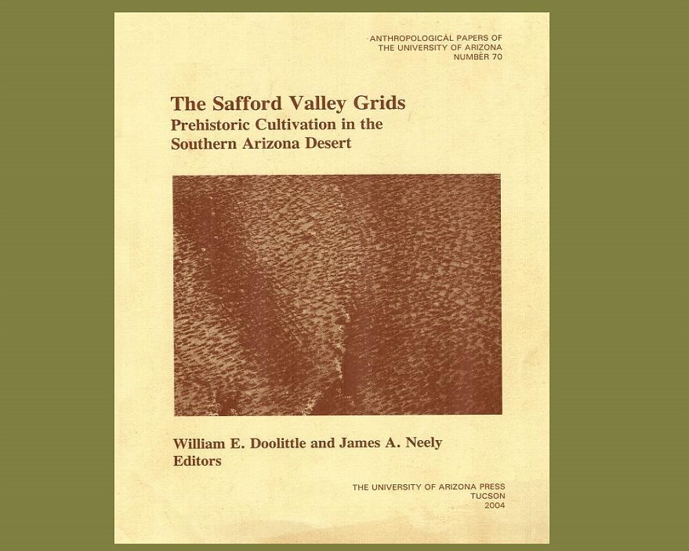
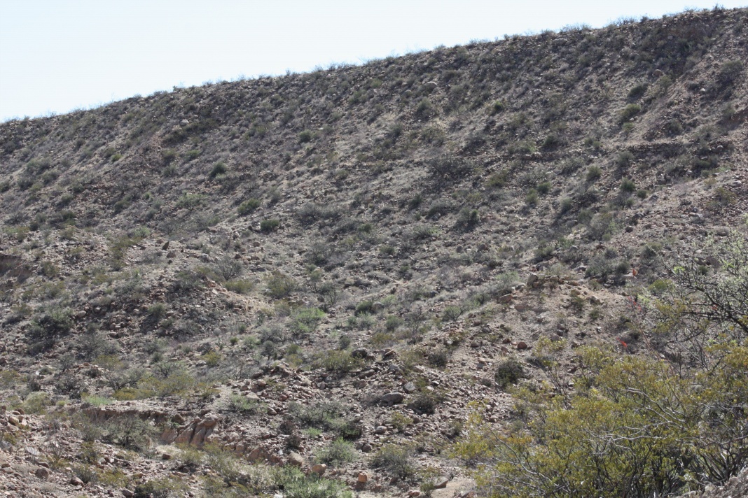
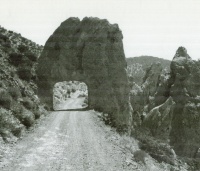
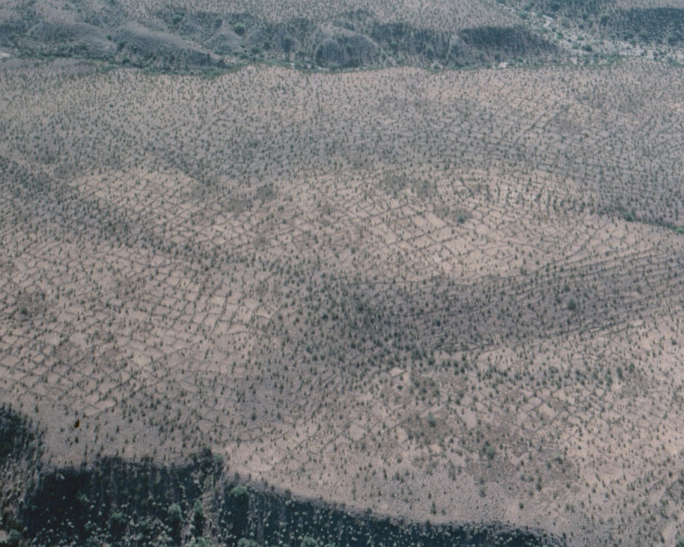
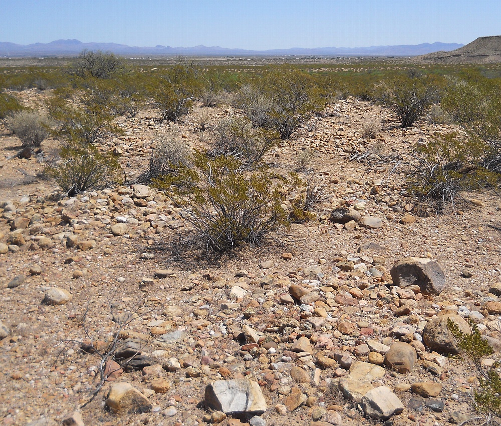
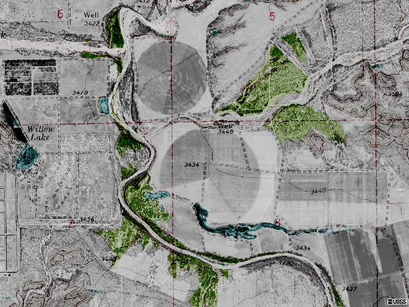
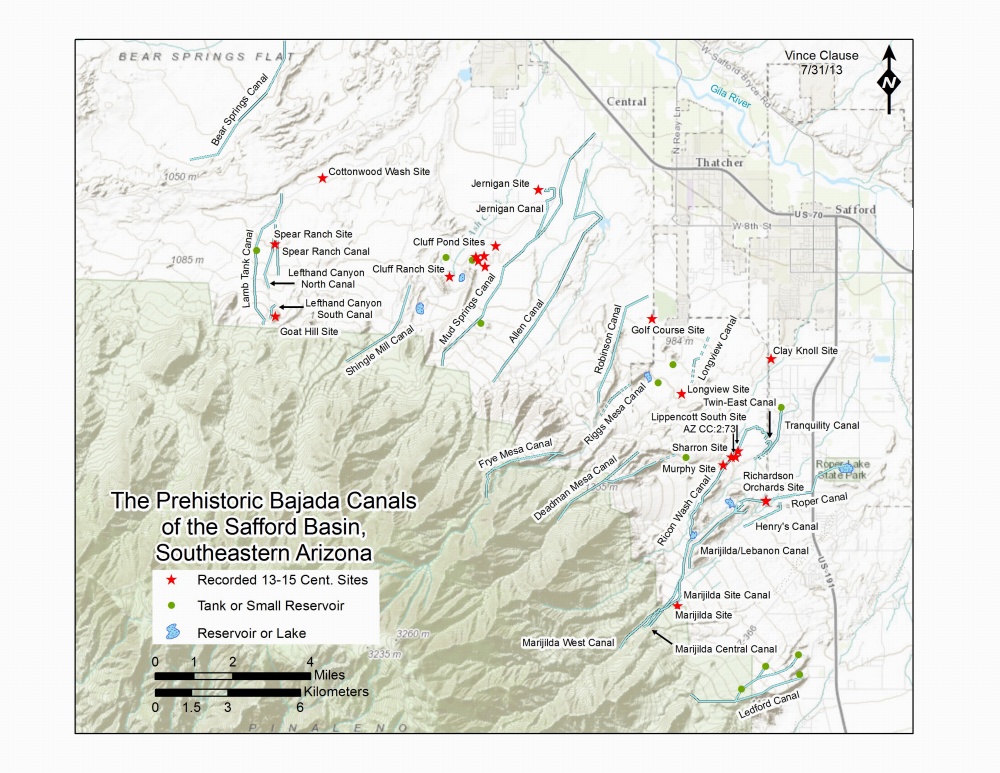
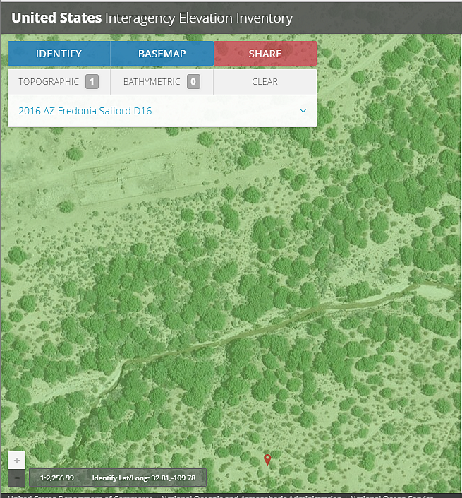
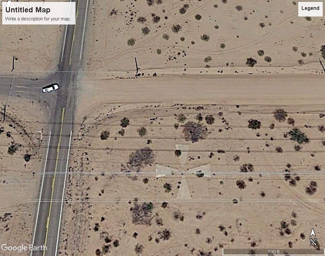
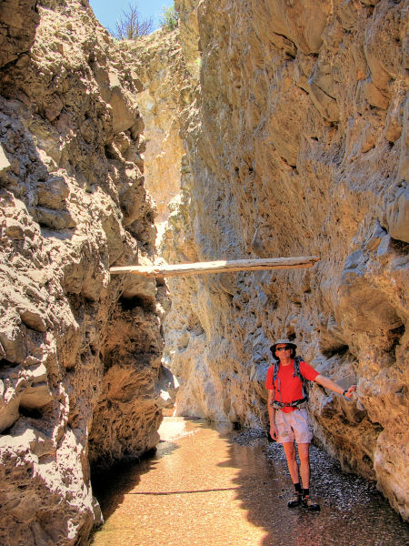
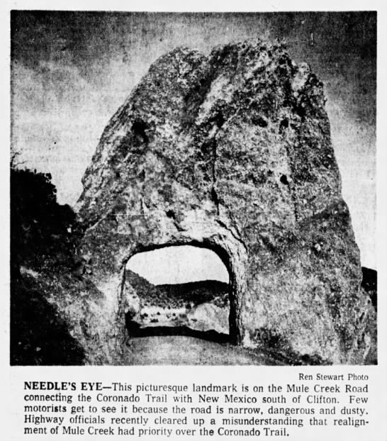
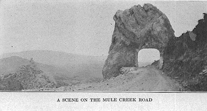
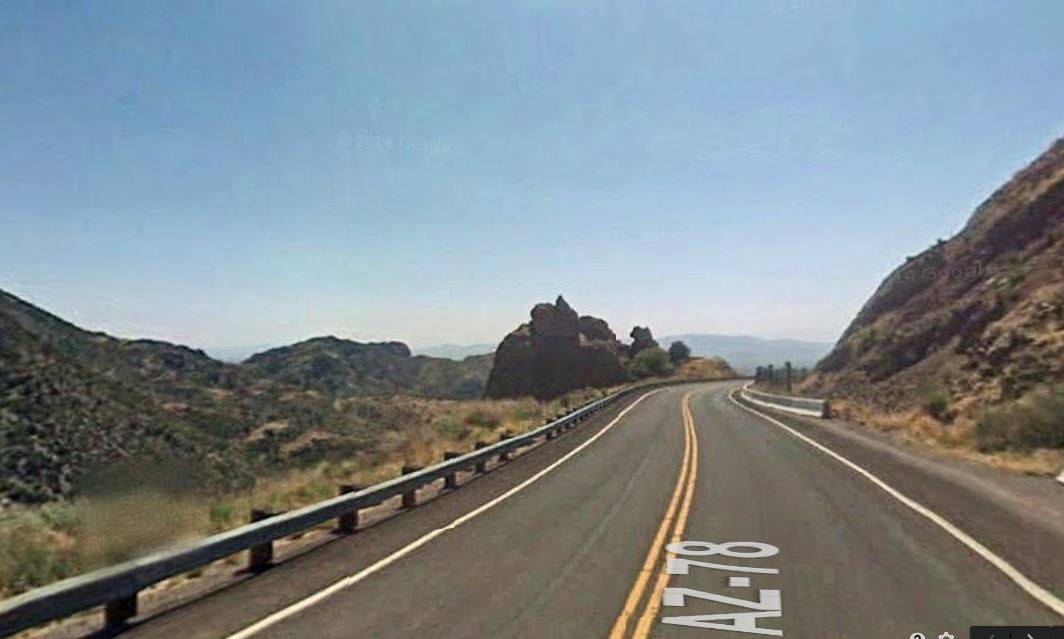
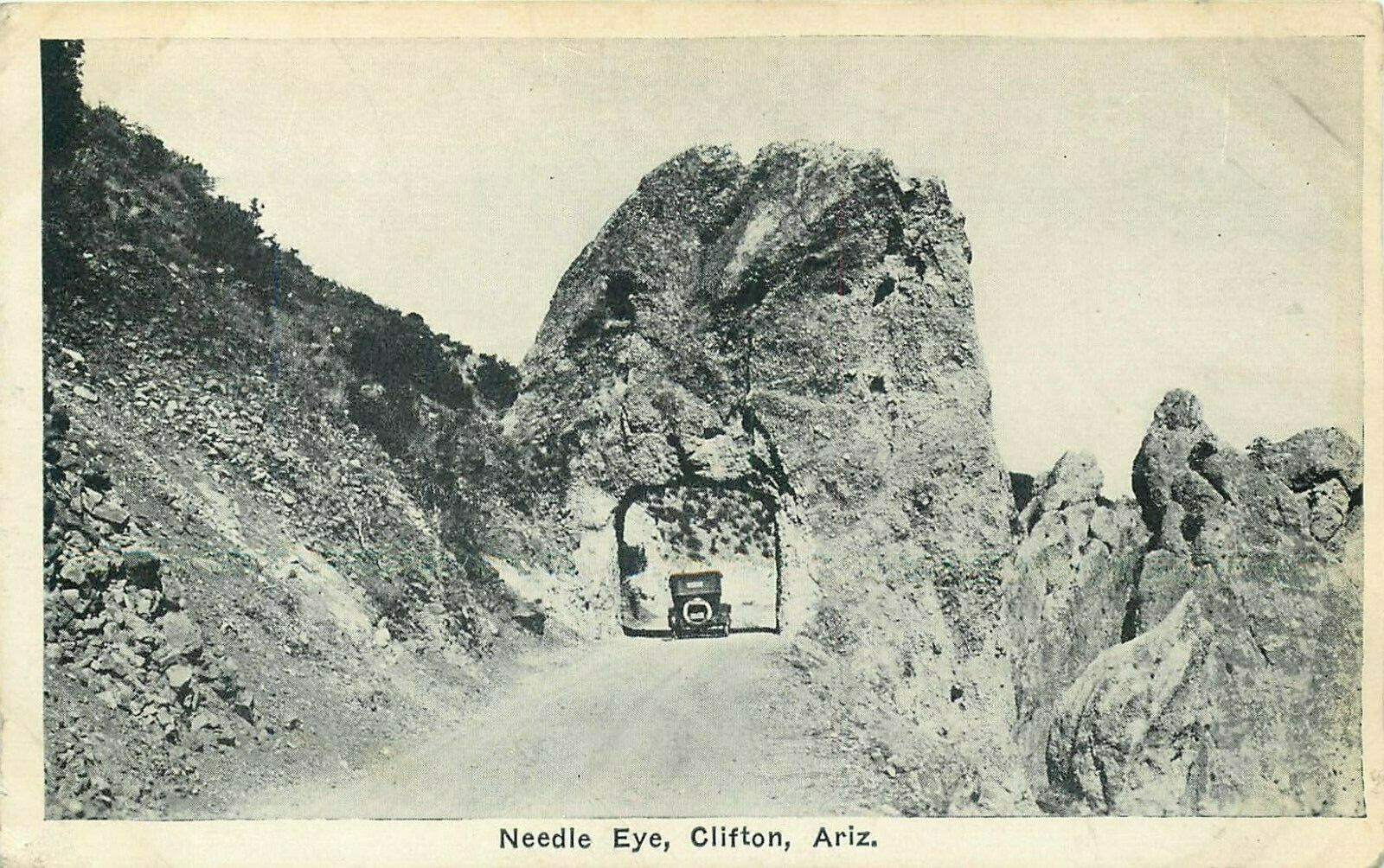
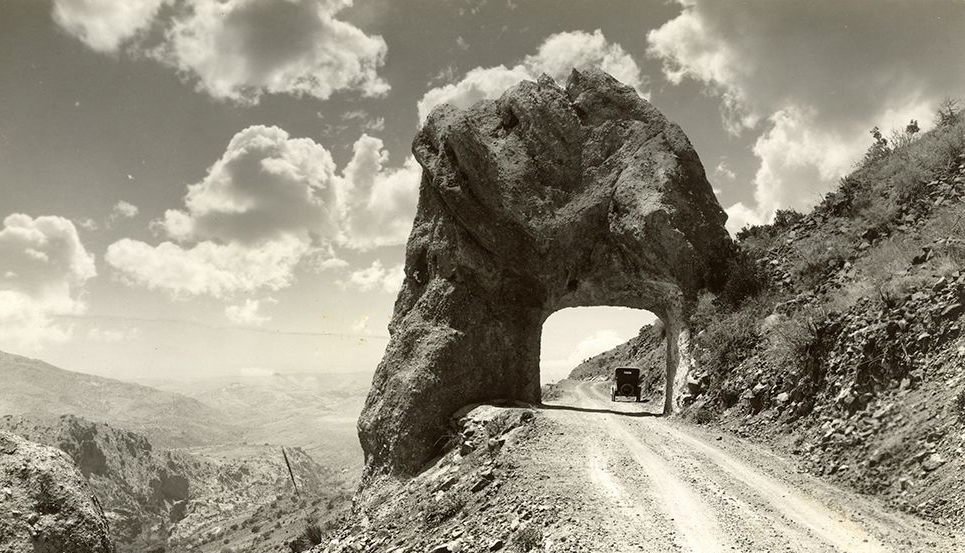
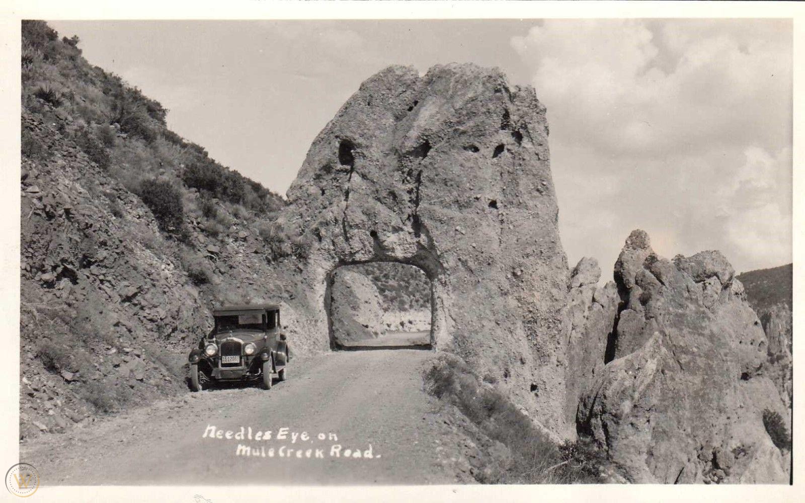
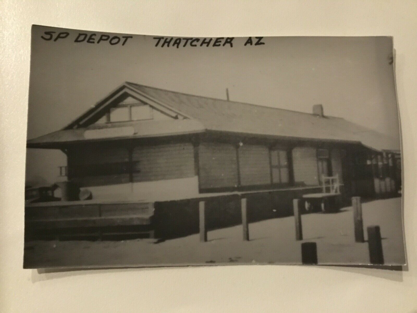
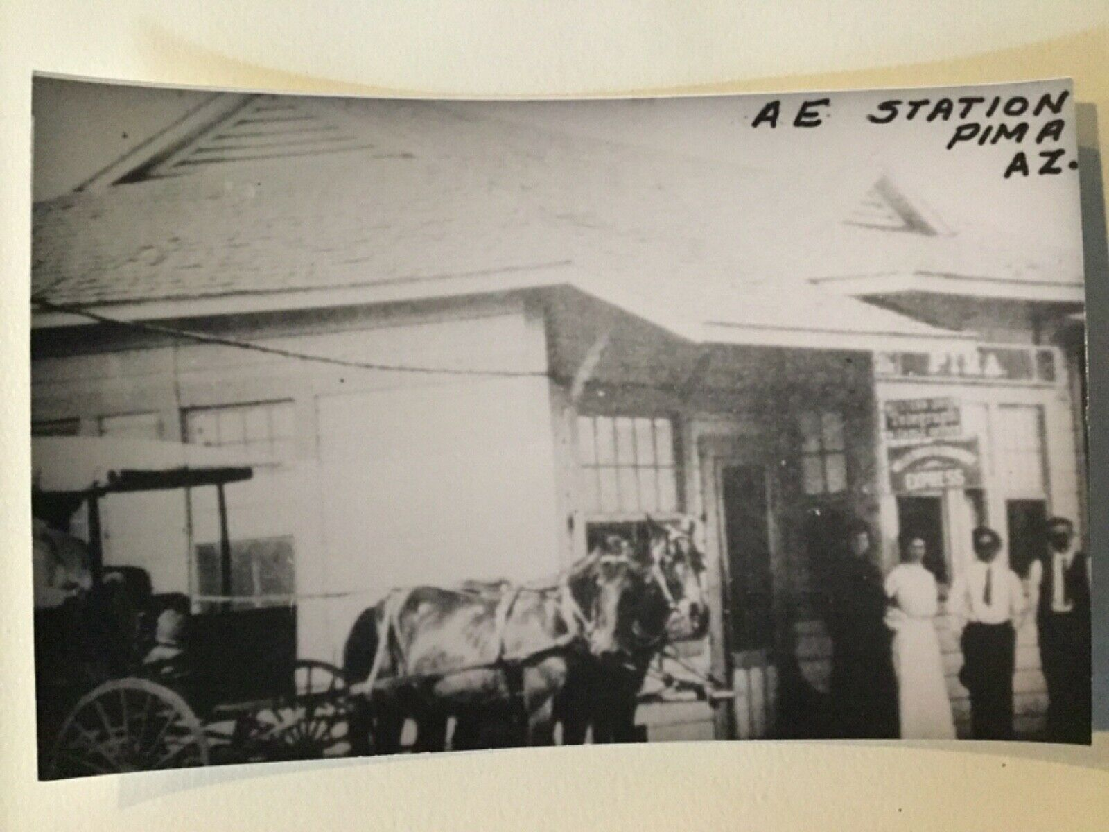